IMAGES TAKEN NEAR TO
Tytherleigh, AXMINSTER, EX13 7BE
Introduction
This page details the photographs taken nearby to EX13 7BE by members of the Geograph project.
The Geograph project started in 2005 with the aim of publishing, organising and preserving representative images for every square kilometre of Great Britain, Ireland and the Isle of Man.

There are currently over 7.5m images from over14,400 individuals and you can help contribute to the project by visiting https://www.geograph.org.uk
Image Map
Images are licensed for reuse under creativecommons.org/licenses/by-sa/2.0
Notes
- Clicking on the map will re-center to the selected point.
- The higher the marker number, the further away the image location is from the centre of the postcode.
Image Listing (16 Images Found)
Images are licensed for reuse under creativecommons.org/licenses/by-sa/2.0
Image
Details
Distance
2
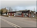
Vintage Shop Front
A view of the front of the Vintage Trading Post in Tytherleigh, Devon as viewed from the carpark on the A358.
Image: © John P Reeves
Taken: 3 Sep 2022
0.02 miles
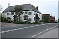
4

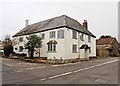
The Tytherleigh Arms
A former coaching inn dating back to the 16th century. It is now a B&B and restaurant as well as the local inn.
Image: © Eirian Evans
Taken: 28 Oct 2021
0.03 miles
5
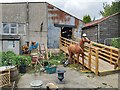
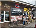
Rear of Vintage Shop
A view of the rear of the Vintage Trading Post, situated on the A358 in Tytherleigh, Devon.
Image: © John P Reeves
Taken: 3 Sep 2022
0.04 miles
6
Chardstock: The Tytherleigh Arms
By the turning to Chardstock village and on the A358 from Axminster to Chard. Centuries earlier the Fosse Way was an active road less than a field’s length away to the right. In the recently published book ‘Voices of Chardstock’ there is a photograph of the pub’s skittle alley, opened circa 1955
Image: © Martin Bodman
Taken: 30 Apr 2006
0.05 miles
7
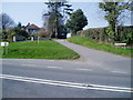
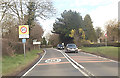
Road junction at Greenhays Foot
Storridge Lane leading to Chardstock branches off A358.
Image: © Peter Holmes
Taken: 18 Mar 2009
0.10 miles
8

Footpath at rear of houses in Broom Lane
Public footpath linking Crabwell Farm with A358.
Image: © Peter Holmes
Taken: 18 Mar 2009
0.10 miles
9
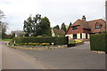
House in Tytherleigh
This very neat detached house in the village has a rather tatty little sign announcing its name as Gransden Cottage. It is on Broom Lane close to its junction with the A358 Axminster to Chard road.
Image: © Nigel Mykura
Taken: 12 Mar 2017
0.14 miles