IMAGES TAKEN NEAR TO
Whitford Road, AXMINSTER, EX13 7AN
Introduction
This page details the photographs taken nearby to Whitford Road, EX13 7AN by members of the Geograph project.
The Geograph project started in 2005 with the aim of publishing, organising and preserving representative images for every square kilometre of Great Britain, Ireland and the Isle of Man.

There are currently over 7.5m images from over14,400 individuals and you can help contribute to the project by visiting https://www.geograph.org.uk
Image Map
Images are licensed for reuse under creativecommons.org/licenses/by-sa/2.0
Notes
- Clicking on the map will re-center to the selected point.
- The higher the marker number, the further away the image location is from the centre of the postcode.
Image Listing (19 Images Found)
Images are licensed for reuse under creativecommons.org/licenses/by-sa/2.0
Image
Details
Distance
1
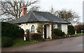
Old Toll House by Whitford Road, Millands
Toll House in the parish of Musbury (East Devon District), Turnpike Cottage, Whitford Road, Millands, EX13 7AN.
Devon & Dartmoor HER.
HER Number: MDV28388 https://www.heritagegateway.org.uk/Gateway/Results_Single.aspx?uid=MDV28388&resourceID=104
Surveyed
Milestone Society National ID: DV.MUS
Image: © Alan Rosevear
Taken: 6 Jan 2008
0.00 miles
2
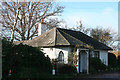
Musbury: Turnpike Cottage
On the Musbury-Whitford road at the junction with Waterford Lane. Looking west
Image: © Martin Bodman
Taken: 16 Dec 2006
0.01 miles
3
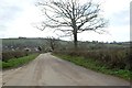
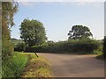
On the road to Musbury
Between Whitford and Musbury, taken from the junction with Maidenhayne Lane.
Image: © Trevor Harris
Taken: 30 Mar 2015
0.08 miles
4

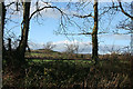
Whitford Road, Musbury
The hedge on the left marks the transition from housing to farmland
Image: © David Smith
Taken: 25 Jun 2016
0.13 miles
5
Musbury: Waterford Lane
Looking west-north-west across the Axe valley
Image: © Martin Bodman
Taken: 16 Dec 2006
0.14 miles
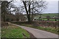
6
Whitford Road
The road from Whitford to Musbury rounding a double bend, with a ditch and a leaning guide post that may have saved a motorist from it.
Image: © Derek Harper
Taken: 15 Sep 2012
0.14 miles
7
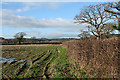
Musbury: near Millands Farm
Looking west-north-west across farmland in the Axe valley
Image: © Martin Bodman
Taken: 16 Dec 2006
0.17 miles
8
East Devon : Maidenhayne Lane
Maidenhayne Lane leading to Whitford Road in East Devon.
Image: © Lewis Clarke
Taken: 16 Feb 2012
0.18 miles
9
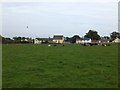
Cows near the chapel in Whitford Road, Musbury
Image: © David Smith
Taken: 27 Sep 2013
0.18 miles
10
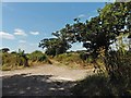
Track leading north from Maidenhayne Lane
Image: © Roger Cornfoot
Taken: 25 Jul 2018
0.19 miles