IMAGES TAKEN NEAR TO
Hawkchurch, AXMINSTER, EX13 5XN
Introduction
This page details the photographs taken nearby to EX13 5XN by members of the Geograph project.
The Geograph project started in 2005 with the aim of publishing, organising and preserving representative images for every square kilometre of Great Britain, Ireland and the Isle of Man.

There are currently over 7.5m images from over14,400 individuals and you can help contribute to the project by visiting https://www.geograph.org.uk
Image Map
Images are licensed for reuse under creativecommons.org/licenses/by-sa/2.0
Notes
- Clicking on the map will re-center to the selected point.
- The higher the marker number, the further away the image location is from the centre of the postcode.
Image Listing (16 Images Found)
Images are licensed for reuse under creativecommons.org/licenses/by-sa/2.0
Image
Details
Distance
1
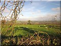
Sheep by Pound Road
The field shown in Image], seen from about 130 metres southeast of the junction.
Image: © Derek Harper
Taken: 23 Nov 2013
0.07 miles
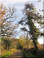
2
Pound Road
A reverse view of Image], taken from beside the larch. Trees hide Pound Farm on the right.
Image: © Derek Harper
Taken: 23 Nov 2013
0.08 miles
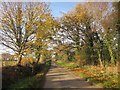
3
Pound Road
Taken just south of Pound Farm, with trees leaning strangely in, among them a spooky-looking ivy-clad larch.
Image: © Derek Harper
Taken: 23 Nov 2013
0.10 miles
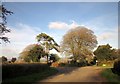
4

View from Pound Road
Looking towards the Blackwater valley from above Pound.
Image: © Derek Harper
Taken: 23 Nov 2013
0.14 miles
5
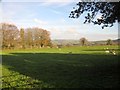
Sheep, Hawkchurch Cross
Sheep graze in the field on the east side of Image
Image: © Derek Harper
Taken: 23 Nov 2013
0.15 miles
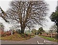
6
Hawkchurch Cross
A crossroads high above the village of Hawkchurch. Wareham Road is crossed by Hawkchurch Road (left) and Pound Road (right).
Image: © Derek Harper
Taken: 23 Nov 2013
0.17 miles
7

View from Pound Road
Looking to the right from the same spot as Image], with overlap; the bare tree in the field, which I think is a copper beech, is in both images. The tree in the centre looks like a larch. The wood on the right is Main Covert.
Image: © Derek Harper
Taken: 23 Nov 2013
0.17 miles
9
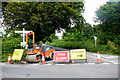
Road Closed at Hawkchurch Cross
A plethora of sign at the crossroads showing the road to Westhay is closed. As well as the roadworks signs the finger post sign is well populated with additional signs for a hotel and the local village shop. The closed road is Wareham Road which is an unusual name as it is long way from Wareham and there does not appear to be any local location with that name.
Image: © Nigel Mykura
Taken: 15 Jun 2015
0.18 miles
10

By Hawkchurch Cross
Taken at Image], with Hawkchurch Road on the left and a glimpse across countryside on the right.
Image: © Derek Harper
Taken: 23 Nov 2013
0.19 miles