IMAGES TAKEN NEAR TO
Trinity Hill Road, AXMINSTER, EX13 5SL
Introduction
This page details the photographs taken nearby to Trinity Hill Road, EX13 5SL by members of the Geograph project.
The Geograph project started in 2005 with the aim of publishing, organising and preserving representative images for every square kilometre of Great Britain, Ireland and the Isle of Man.

There are currently over 7.5m images from over14,400 individuals and you can help contribute to the project by visiting https://www.geograph.org.uk
Image Map
Images are licensed for reuse under creativecommons.org/licenses/by-sa/2.0
Notes
- Clicking on the map will re-center to the selected point.
- The higher the marker number, the further away the image location is from the centre of the postcode.
Image Listing (8 Images Found)
Images are licensed for reuse under creativecommons.org/licenses/by-sa/2.0
Image
Details
Distance
1

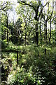
Trinity Hill Nature Reserve
More info: http://tinyurl.com/g2vzo , http://www.countrysideinfo.co.uk/trinity.htm
Image: © Katy Walters
Taken: 22 Jul 2006
0.16 miles
3
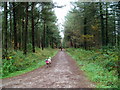
Public Bridleway, Trinity Hill
Route to Hoyton Hill and Woodhouse Hill.
Image: © Peter Holmes
Taken: 14 Nov 2008
0.19 miles
4

Gateway into Woolly Wood
This large double gateway gives access to the woods just below St Mary's on Woolly hill where several large luxury homes have been built mostly with swimming pools.
Image: © Nigel Mykura
Taken: 29 Sep 2017
0.19 miles
5
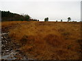
Trinity Hill Nature Reserve
A damp November afternoon, contrast this with a similar view showing dry conditions in July. http://www.geograph.org.uk/photo/231619
Image: © Peter Holmes
Taken: 14 Nov 2008
0.20 miles

7
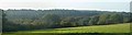
Woolly Hill and Hoyton Hill
Panorama of Woolly Hill and Hoyton Hill taken From Yawl Hill.
Image: © A person
Taken: 2 Oct 2011
0.24 miles
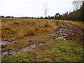
8
Trinity Hill Nature Reserve
Muddy access land on a damp November day.
Image: © Peter Holmes
Taken: 14 Nov 2008
0.25 miles