IMAGES TAKEN NEAR TO
Cooks Lane, AXMINSTER, EX13 5SJ
Introduction
This page details the photographs taken nearby to Cooks Lane, EX13 5SJ by members of the Geograph project.
The Geograph project started in 2005 with the aim of publishing, organising and preserving representative images for every square kilometre of Great Britain, Ireland and the Isle of Man.

There are currently over 7.5m images from over14,400 individuals and you can help contribute to the project by visiting https://www.geograph.org.uk
Image Map
Images are licensed for reuse under creativecommons.org/licenses/by-sa/2.0
Notes
- Clicking on the map will re-center to the selected point.
- The higher the marker number, the further away the image location is from the centre of the postcode.
Image Listing (12 Images Found)
Images are licensed for reuse under creativecommons.org/licenses/by-sa/2.0
Image
Details
Distance
1
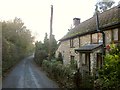
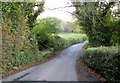
Cottage on Cook's Lane
The lane from Raymond's Hill to Axminster passes Furzeleigh Cottage. This stretch of the lane is used by both NCN2 and the Buzzard Route, regional cycle route 52.
Image: © Derek Harper
Taken: 23 Nov 2013
0.04 miles
2
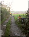
Track to Furzeleigh Farm
Axminster Footpath 21 follows this farm track from a double bend on Cook's Lane. That's a cow 60 metres away, but there's a cattle grid between her and the road.
Image: © Derek Harper
Taken: 23 Nov 2013
0.12 miles
4
Cook's Lane
Crossing a small tributary of the Mill Brook. The lane is followed here by both NCN2 and the Buzzard Route, regional cycle route 52. It's gettig very gloomy - time to call a halt to photography, plus I've a bus to catch in Axminster. Just as well; on examination this image is a bit blurry.
Image: © Derek Harper
Taken: 23 Nov 2013
0.21 miles
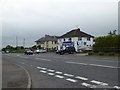
5

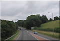
A35 minor road junction
This junction is just west of Raymonds Hill.
Image: © Stuart Buchan
Taken: 6 May 2006
0.22 miles
6
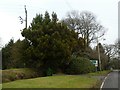
Dense evergreens by Trinity Hill Road buffering road noise
These evergreens shield the houses on the left from the noise from the A35 at the foot of the hill ahead. They also hide part of the road sign.
Image: © David Smith
Taken: 30 Dec 2019
0.22 miles
7
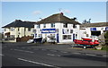
Boating Centre by A35 near Raymond's Hill
Image: © David Smith
Taken: 1 Jun 2016
0.22 miles