IMAGES TAKEN NEAR TO
Willhay Lane, AXMINSTER, EX13 5RW
Introduction
This page details the photographs taken nearby to Willhay Lane, EX13 5RW by members of the Geograph project.
The Geograph project started in 2005 with the aim of publishing, organising and preserving representative images for every square kilometre of Great Britain, Ireland and the Isle of Man.

There are currently over 7.5m images from over14,400 individuals and you can help contribute to the project by visiting https://www.geograph.org.uk
Image Map
Images are licensed for reuse under creativecommons.org/licenses/by-sa/2.0
Notes
- Clicking on the map will re-center to the selected point.
- The higher the marker number, the further away the image location is from the centre of the postcode.
Image Listing (17 Images Found)
Images are licensed for reuse under creativecommons.org/licenses/by-sa/2.0
Image
Details
Distance
4
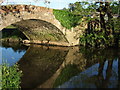
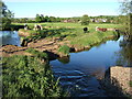
Bridge over River Axe
Another view of Image, showing the southern end of the bridge.
Image: © Derek Harper
Taken: 17 May 2007
0.14 miles
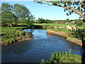
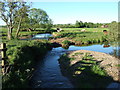
5
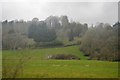
Meander on River Axe
The cattle are standing within a meander, on what is likely to become an island in a very few years, as the river is rapidly eroding the neck. The houses in the background are on Willhay Lane, at the northern edge of Axminster. Seen from Axminster Footpath 45.
Image: © Derek Harper
Taken: 17 May 2007
0.15 miles
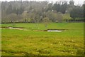
6
River Axe
See Image; the cattle are grazing within the meander, oblivious to the precarious nature of their link to the outside world. The river is flowing away from the camera as it prepares to bend around to the right. Houses on Willhay Lane are visible behind.
Image: © Derek Harper
Taken: 17 May 2007
0.15 miles
8
Bridge over River Axe
The Axe a little north of Axminster, crossed here by the drive to Cloakham. Looking upstream.
Image: © Derek Harper
Taken: 17 May 2007
0.15 miles
9
Meander on River Axe
Another view of Image, showing trees on the upstream side of the bend; the river is flowing towards the camera in the foreground.
Image: © Derek Harper
Taken: 17 May 2007
0.15 miles
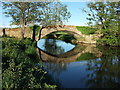
10
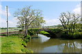
Bridge to Cloakham
This elegant low-arched bridge takes the track to Cloakham and Sisterhood Farm across the River Axe. It also carries a bridle path.
Image: © Nigel Mykura
Taken: 23 May 2015
0.17 miles