IMAGES TAKEN NEAR TO
AXMINSTER, EX13 5RN
Introduction
This page details the photographs taken nearby to EX13 5RN by members of the Geograph project.
The Geograph project started in 2005 with the aim of publishing, organising and preserving representative images for every square kilometre of Great Britain, Ireland and the Isle of Man.

There are currently over 7.5m images from over14,400 individuals and you can help contribute to the project by visiting https://www.geograph.org.uk
Image Map
Images are licensed for reuse under creativecommons.org/licenses/by-sa/2.0
Notes
- Clicking on the map will re-center to the selected point.
- The higher the marker number, the further away the image location is from the centre of the postcode.
Image Listing (12 Images Found)
Images are licensed for reuse under creativecommons.org/licenses/by-sa/2.0
Image
Details
Distance
1
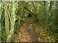
Vineyard Lane
Overgrown track, more like a stream.
Image: © Peter Holmes
Taken: 13 Nov 2008
0.06 miles
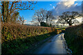
2
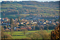
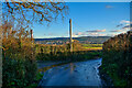
Axminster : Countryside Scenery
Looking down into Axminster.
Image: © Lewis Clarke
Taken: 31 Dec 2020
0.06 miles
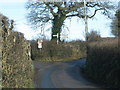
3
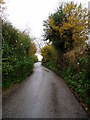
Up Fourcross Hill
Narrow Devon lane between Axminster and Membury.
Image: © Peter Holmes
Taken: 13 Nov 2008
0.14 miles
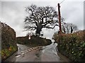
4
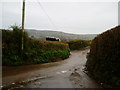
Cattle viewing Four Cross
Looking downhill towards Axminster.
Image: © Peter Holmes
Taken: 13 Nov 2008
0.20 miles
6
Axminster : Uphay Lane
Looking along Uphay Lane.
Image: © Lewis Clarke
Taken: 31 Dec 2020
0.21 miles
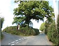
9
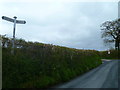
Orange Way in Devon and Torbay (495)
This is looking back from the signpost at the north west end of Fourcross Hill. The Orange Way has come from the left road at the fork.
Image: © Shazz
Taken: 18 Apr 2012
0.22 miles
10
Axminster : Four Cross
Looking along Four Cross.
Image: © Lewis Clarke
Taken: 31 Dec 2020
0.22 miles