IMAGES TAKEN NEAR TO
Albert Terrace, North Street, AXMINSTER, EX13 5QQ
Introduction
This page details the photographs taken nearby to Albert Terrace, North Street, EX13 5QQ by members of the Geograph project.
The Geograph project started in 2005 with the aim of publishing, organising and preserving representative images for every square kilometre of Great Britain, Ireland and the Isle of Man.

There are currently over 7.5m images from over14,400 individuals and you can help contribute to the project by visiting https://www.geograph.org.uk
Image Map
Images are licensed for reuse under creativecommons.org/licenses/by-sa/2.0
Notes
- Clicking on the map will re-center to the selected point.
- The higher the marker number, the further away the image location is from the centre of the postcode.
Image Listing (104 Images Found)
Images are licensed for reuse under creativecommons.org/licenses/by-sa/2.0
Image
Details
Distance
1
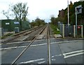
Orange Way in Devon and Torbay (497)
This is the railway line looking north east from Axminster level crossing at the bottom of Castle Hill.
Image: © Shazz
Taken: 18 Apr 2012
0.10 miles
2

Latches Walk, Axminster
From Chard Road, Latches Walk leads to Latchmount Gardens.
Image: © Jaggery
Taken: 9 Mar 2017
0.12 miles
3
From Chard Street to Chard Road, Axminster
Near the Latches Walk junction on the right, a sign shows that Chard Street is on the left, Chard Road on the right. The street and road are part of the A358.
Image: © Jaggery
Taken: 9 Mar 2017
0.13 miles
5
Entrance to Axminster Hospital
From the A358 Chard Street. A 5 mph speed limit is in force in the hospital grounds.
Image: © Jaggery
Taken: 9 Mar 2017
0.14 miles
6
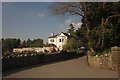
Victorian villa, Axminster
Brookhill is a detached villa set back from the Chard Road, and gradually becoming surrounded by modern housing developments.
Image: © Derek Harper
Taken: 25 May 2013
0.14 miles
7
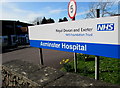
Axminster Hospital name board, Axminster
Axminster Hospital is part of the Royal Devon and Exeter NHS Foundation Trust.
The main hospital entrance is on the left.
Image: © Jaggery
Taken: 9 Mar 2017
0.14 miles
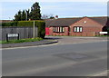
8

Three nameboards facing Lyme Road, Axminster
On the left here https://www.geograph.org.uk/photo/6747272 viewed in March 2017. The boards show
The Axe Valley Community College & Sixth Form Centre
Leisure Centre Axminster
the flamingo pool
Image: © Jaggery
Taken: 9 Mar 2017
0.14 miles
9
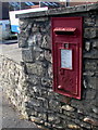
King George VI postbox outside Axminster Hospital
In the wall on the right here. http://www.geograph.org.uk/photo/5321068
Image: © Jaggery
Taken: 9 Mar 2017
0.14 miles
10

From 20 to 30 on Chard Street, Axminster
On the ascent away from the town centre, the 20mph speed limit on the A358 Chard Street increases to 30mph.
A few tens of metres ahead, the A358 Chard Street becomes the A358 Chard Road.
Image: © Jaggery
Taken: 9 Mar 2017
0.15 miles