IMAGES TAKEN NEAR TO
Poplar Mount, AXMINSTER, EX13 5QE
Introduction
This page details the photographs taken nearby to Poplar Mount, EX13 5QE by members of the Geograph project.
The Geograph project started in 2005 with the aim of publishing, organising and preserving representative images for every square kilometre of Great Britain, Ireland and the Isle of Man.

There are currently over 7.5m images from over14,400 individuals and you can help contribute to the project by visiting https://www.geograph.org.uk
Image Map
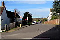
Images are licensed for reuse under creativecommons.org/licenses/by-sa/2.0
Notes
- Clicking on the map will re-center to the selected point.
- The higher the marker number, the further away the image location is from the centre of the postcode.
Image Listing (268 Images Found)
Images are licensed for reuse under creativecommons.org/licenses/by-sa/2.0
Image
Details
Distance
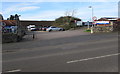
1
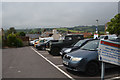
Axminster : Car Park
A car park off of Poplar Mount.
Image: © Lewis Clarke
Taken: 9 Jul 2016
0.04 miles
2

This way to Poplar Mount car park, Axminster
From the A358 Chard Street along Poplar Mount towards Poplar Mount long stay pay & display car park.
Image: © Jaggery
Taken: 9 Mar 2017
0.05 miles
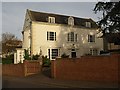
3
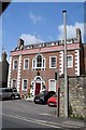
Oak House, Axminster
A Georgian style house, now a residential care home.
Image: © Trevor Harris
Taken: 2 Aug 2019
0.05 miles
4
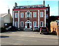
Oak House, Chard Street, Axminster
In March 2017, Oak House is a care home. The Historical Axminster blue plaque on the building records that Oak House was built for Simon Bunter, a local solicitor, in 1758. It remained a private dwelling until about the middle of the 19th century when it became a preparatory school for boys. It was later purchased by the owners of Dawkin's Stores and used as a hostel for resident staff. For some years it was the offices of the urban and rural District Councils.
Oak House was Grade II (star) listed in 1950.
Image: © Jaggery
Taken: 9 Mar 2017
0.05 miles
5
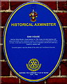
Oak House blue plaque, Chard Street, Axminster
The Historical Axminster plaque is on the wall here. http://www.geograph.org.uk/photo/5321749
Image: © Jaggery
Taken: 9 Mar 2017
0.05 miles

7
Southern end of North Street, Axminster
The North Street junction has Victoria Place to the right and Castle Hill to the left.
Image: © Jaggery
Taken: 9 Mar 2017
0.05 miles
8

Chard Street at entrance to Axminster hospital
Image: © John Firth
Taken: 12 Apr 2013
0.05 miles
9
Entrance to Axminster Hospital
From the A358 Chard Street. A 5 mph speed limit is in force in the hospital grounds.
Image: © Jaggery
Taken: 9 Mar 2017
0.06 miles
10
Castle Hill House, Axminster
This attractive building is, according to the notice outside, the local Kingdom Hall of Jehovah's Witnesses. Rusticated quoins and a little Venetian window.
Image: © Derek Harper
Taken: 21 Nov 2008
0.06 miles