IMAGES TAKEN NEAR TO
Fosseway Close, AXMINSTER, EX13 5LW
Introduction
This page details the photographs taken nearby to Fosseway Close, EX13 5LW by members of the Geograph project.
The Geograph project started in 2005 with the aim of publishing, organising and preserving representative images for every square kilometre of Great Britain, Ireland and the Isle of Man.

There are currently over 7.5m images from over14,400 individuals and you can help contribute to the project by visiting https://www.geograph.org.uk
Image Map
Images are licensed for reuse under creativecommons.org/licenses/by-sa/2.0
Notes
- Clicking on the map will re-center to the selected point.
- The higher the marker number, the further away the image location is from the centre of the postcode.
Image Listing (294 Images Found)
Images are licensed for reuse under creativecommons.org/licenses/by-sa/2.0
Image
Details
Distance
1
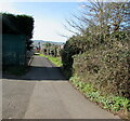
Side road and public footpath in Axminster
Looking to the west from Lyme Close. A public footpath direction sign https://www.geograph.org.uk/photo/6747607 is nearby.
Image: © Jaggery
Taken: 9 Mar 2017
0.02 miles
2

Axminster high-voltage substation
Large Western Power Distribution site set back from Lyme Close in Axminster, Devon.
Image: © Jaggery
Taken: 9 Mar 2017
0.02 miles
3
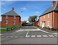
Fosseway Close, Axminster
Fosseway Close leads to Fairfield Close and Auction Place.
Image: © Jaggery
Taken: 9 Mar 2017
0.02 miles
4

Public footpath direction sign in a hedge, Axminster
The white arrow on the sign on the corner of Lyme Close points west towards this https://www.geograph.org.uk/photo/6747589 side road.
Image: © Jaggery
Taken: 9 Mar 2017
0.04 miles
5

Grass triangle, Lyme Close, Axminster
Roughly triangular area of (mostly) grass viewed in March 2017.
Axminster high-voltage substation https://www.geograph.org.uk/photo/6747449 is in the background.
Image: © Jaggery
Taken: 9 Mar 2017
0.04 miles
6
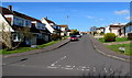
Welch Close, Axminster
Cul-de-sac viewed across Lyme Close.
Image: © Jaggery
Taken: 9 Mar 2017
0.05 miles
7
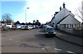
Coombefield Lane, Axminster
Looking to the SE from the corner of Coombe Lane in March 2017.
Coombe Lane Long Stay Car Park is on the left.
Image: © Jaggery
Taken: 9 Mar 2017
0.05 miles
8

Axminster Fire Station
Axminster Fire Station, Lyme Close, Axminster, Devon.
Image: © Kevin Hale
Taken: 30 Jun 1991
0.05 miles
9

South along Lyme Close, Axminster
Ahead for Axminster Fire Station. https://www.geograph.org.uk/photo/6747433 Behind the camera for the B3261 Lyme Road.
Image: © Jaggery
Taken: 9 Mar 2017
0.05 miles
10
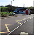
Zigzag markings on Lyme Close, Axminster
The yellow markings define the Keep Clear Zone near Axminster Community Fire Station. http://www.geograph.org.uk/photo/5306661
Image: © Jaggery
Taken: 9 Mar 2017
0.06 miles