IMAGES TAKEN NEAR TO
Lyme Close, AXMINSTER, EX13 5BB
Introduction
This page details the photographs taken nearby to Lyme Close, EX13 5BB by members of the Geograph project.
The Geograph project started in 2005 with the aim of publishing, organising and preserving representative images for every square kilometre of Great Britain, Ireland and the Isle of Man.

There are currently over 7.5m images from over14,400 individuals and you can help contribute to the project by visiting https://www.geograph.org.uk
Image Map
Images are licensed for reuse under creativecommons.org/licenses/by-sa/2.0
Notes
- Clicking on the map will re-center to the selected point.
- The higher the marker number, the further away the image location is from the centre of the postcode.
Image Listing (224 Images Found)
Images are licensed for reuse under creativecommons.org/licenses/by-sa/2.0
Image
Details
Distance
1
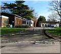
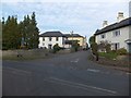
Former Magistrates Court and former Police Station, Axminster
Set back from Lyme Close near the B3261 Lyme Road junction.
The Magistrates Court on left dates from 1963.
The Police Station was built a year later.
Image: © Jaggery
Taken: 9 Mar 2017
0.01 miles
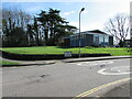
2
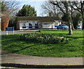
Daffodils on grass, Lyme Close, Axminster
Viewed on March 9th 2017.
Image: © Jaggery
Taken: 9 Mar 2017
0.01 miles
3
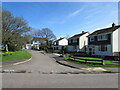
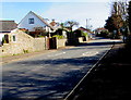
Lyme Close houses, Axminster
Set back from the east side of the main course of Lyme Close.
Image: © Jaggery
Taken: 9 Mar 2017
0.02 miles
4
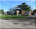
Former Magistrates Court, Axminster
Viewed in March 2017. The Magistrates Court which closed in 2001 dates from 1963.
A notice on the wall on the left shows MAGISTRATES ONLY.
Image: © Jaggery
Taken: 9 Mar 2017
0.02 miles
5

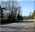
Lyme Road direction signs and electricity substation, Axminster
Opposite the Stoney Lane junction 12 miles from Bridport.
The Western Power Distribution electricity substation identifier is POLICE STATION 251756.
Image: © Jaggery
Taken: 9 Mar 2017
0.03 miles
6
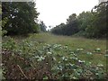
Rough ground on the Lyme Road, Axminster
A field which extends south from the Lyme Road, now bounded by housing on each side.
Image: © David Smith
Taken: 27 Sep 2013
0.03 miles
7
20 on Lyme Road, Axminster
A 20mph speed limit is in force on this part of the B3261 near a primary school.
Image: © Jaggery
Taken: 9 Mar 2017
0.03 miles
8
Stony Lane, Axminster
A turning off the Lyme Road which gives a short cut to the north of the town and avoids the centre.
Image: © David Smith
Taken: 27 Sep 2013
0.03 miles
9
Road from Axminster towards Lyme Regis
The B3261 Lyme Road southeast of the Stoney Lane junction.
Image: © Jaggery
Taken: 9 Mar 2017
0.03 miles
10
From 20 to 30, Lyme Close, Axminster
The 20mph speed on the B3261 Lyme Road increases to 30mph on Lyme Close.
The name sign shows that Lyme Close leads to Lea Combe, Combe Close, Fairfield Close, Fosseway Close.
Image: © Jaggery
Taken: 9 Mar 2017
0.03 miles