IMAGES TAKEN NEAR TO
Church Street, AXMINSTER, EX13 5AG
Introduction
This page details the photographs taken nearby to Church Street, EX13 5AG by members of the Geograph project.
The Geograph project started in 2005 with the aim of publishing, organising and preserving representative images for every square kilometre of Great Britain, Ireland and the Isle of Man.

There are currently over 7.5m images from over14,400 individuals and you can help contribute to the project by visiting https://www.geograph.org.uk
Image Map
Images are licensed for reuse under creativecommons.org/licenses/by-sa/2.0
Notes
- Clicking on the map will re-center to the selected point.
- The higher the marker number, the further away the image location is from the centre of the postcode.
Image Listing (307 Images Found)
Images are licensed for reuse under creativecommons.org/licenses/by-sa/2.0
Image
Details
Distance
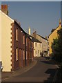
1
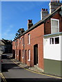
Row of brick houses, Church Street, Axminster
From the corner of Silver Street. The edge of the Axminster Inn http://www.geograph.org.uk/photo/5312637 is on the right.
Image: © Jaggery
Taken: 9 Mar 2017
0.01 miles
2
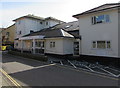
Axminster Medical Practice, Axminster
Located in St Thomas Court, Church Street.
Image: © Jaggery
Taken: 9 Mar 2017
0.01 miles
3
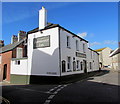
Axminster Inn, Axminster
Town centre pub on the corner of Silver Street and Church Street.
Image: © Jaggery
Taken: 9 Mar 2017
0.02 miles
4
Silver Street towards the Axminster Inn, Axminster
The Axminster Inn http://www.geograph.org.uk/photo/5312637 is in the background.
Image: © Jaggery
Taken: 9 Mar 2017
0.02 miles
5

On-street parking, Church Street, Axminster
On-street parking is allowed on the west side of Church Street.
Double yellow lines on the east side indicate no parking at any time.
Image: © Jaggery
Taken: 9 Mar 2017
0.03 miles
6
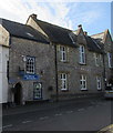
Grade II listed Archway Bookshop, Church Street, Axminster
The Historical Axminster blue plaque on the left records that what is now Archway Bookshop was probably built in the 13th century. Although its original purpose is uncertain, the building was open on the ground floor to allow the passage of carts. A stone stairway to the left-hand side of the door led to the first floor, possibly used as a hayloft or accommodation for the carters.
During the 1700s it was converted to a private house, Church Cottage. In the 1960s it was used by a dental technician. It has been a bookshop since 1966.
The arch forming the doorway is probably a window brought from Newenham Abbey, which was located south of the town and founded in 1246. It was surrendered to the commissioners of Henry VIII in 1539 and was demolished almost immediately. Stone from the Abbey has been used in many Axminster buildings.
Grade II listed in 1950 (as Church Cottage).
Image: © Jaggery
Taken: 9 Mar 2017
0.03 miles
7
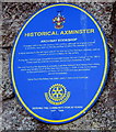
Archway Bookshop blue plaque, Axminster
The Historical Axminster blue plaque is on the left here. http://www.geograph.org.uk/photo/5312664
Image: © Jaggery
Taken: 9 Mar 2017
0.03 miles
8
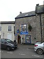
The Archway Bookshop, Axminster
Not originally built as a bookshop (it may date from the 13th century) this is one of the buildings in Axminster given a blue plaque for its contribution to the town's architecture. The plaque is at Image
Image: © David Smith
Taken: 30 Dec 2019
0.03 miles
9
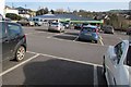
Towards the Co-operative Food store, Axminster
Viewed across a car park on the south side of West Street.
Image: © Jaggery
Taken: 9 Mar 2017
0.03 miles
10
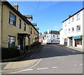
Church Street, Axminster
The junction with Silver Street is in the background.
Image: © Derek Harper
Taken: 25 May 2013
0.03 miles