IMAGES TAKEN NEAR TO
Homefield Road, EX1 2FY
Introduction
This page details the photographs taken nearby to Homefield Road, EX1 2FY by members of the Geograph project.
The Geograph project started in 2005 with the aim of publishing, organising and preserving representative images for every square kilometre of Great Britain, Ireland and the Isle of Man.

There are currently over 7.5m images from over14,400 individuals and you can help contribute to the project by visiting https://www.geograph.org.uk
Image Map
Images are licensed for reuse under creativecommons.org/licenses/by-sa/2.0
Notes
- Clicking on the map will re-center to the selected point.
- The higher the marker number, the further away the image location is from the centre of the postcode.
Image Listing (248 Images Found)
Images are licensed for reuse under creativecommons.org/licenses/by-sa/2.0
Image
Details
Distance
1
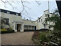
Bramdean School, Exeter
The wall clock shows summer time; the photo was taken at midday on New Year's Day
Image: © David Smith
Taken: 1 Jan 2021
0.02 miles
2

An OS Bench Mark
Situated in Park Place. One of a number in the area.
Image: © Anthony Vosper
Taken: 22 Oct 2022
0.03 miles
3
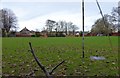
Bramdean School playing field
Seen through the hedge and chain link fence that borders Park Road, Heavitree. An oasis of green amongst the houses
Image: © David Smith
Taken: 23 Nov 2014
0.03 miles
4

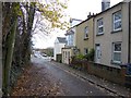
Homefield Road, Exeter
The narrow road widens as it straightens up past the three-storey terrace. The turn on the left is Park Place.
Image: © Derek Harper
Taken: 5 Jan 2009
0.04 miles
5

Homefield Road, Heavitree, Exeter
The junction with Bonnington Grove, signed as part of cycleway E3. The chimney in the middle distance has attractive brickwork
Image: © David Smith
Taken: 23 Jul 2016
0.05 miles
6

Ghost sign, Park Place, Heavitree, Exeter
Image: © David Smith
Taken: 17 May 2020
0.05 miles
7
Park Road, Heavitree, Exeter
A short road with Victorian terraced houses bounded on the opposite side by trees and Bramdean School playing field. Usually, the left hand side of the road is used for parking.
Image: © David Smith
Taken: 23 Nov 2014
0.05 miles
8

Icicles behind Alpha Street, Exeter
Icicles on the north wall, formed from driping water where the snow on the roof has melted (and perhaps the gutter leaks).
Image: © David Smith
Taken: 25 Dec 2010
0.06 miles
9
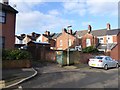
The service road for Bonnington Grove, Exeter
Seen from Goldsmith Street; Bonnington Grove is a street of terraced houses dating from the first quarter of the 20th century
Image: © David Smith
Taken: 20 Jan 2016
0.06 miles
10

Exeter lockdown rainbow, Adam Street
Rainbows in the windows and multi-coloured chalk in the brickwork
Image: © David Smith
Taken: 17 May 2020
0.07 miles