IMAGES TAKEN NEAR TO
Court Barton Hill, SEATON, EX12 3JT
Introduction
This page details the photographs taken nearby to Court Barton Hill, EX12 3JT by members of the Geograph project.
The Geograph project started in 2005 with the aim of publishing, organising and preserving representative images for every square kilometre of Great Britain, Ireland and the Isle of Man.

There are currently over 7.5m images from over14,400 individuals and you can help contribute to the project by visiting https://www.geograph.org.uk
Image Map
Images are licensed for reuse under creativecommons.org/licenses/by-sa/2.0
Notes
- Clicking on the map will re-center to the selected point.
- The higher the marker number, the further away the image location is from the centre of the postcode.
Image Listing (119 Images Found)
Images are licensed for reuse under creativecommons.org/licenses/by-sa/2.0
Image
Details
Distance
1
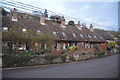
Beer : Almshouses
Almshouses built in 1820 on Townsend.
Image: © Lewis Clarke
Taken: 31 Dec 2017
0.04 miles
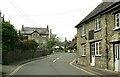
2
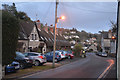
Beer : Townsend
Looking along Townsend as it heads into Beer.
Image: © Lewis Clarke
Taken: 31 Dec 2017
0.05 miles
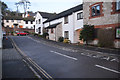
3
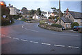
Beer : New Road B3174
A road heading through Beer at the junction with Townsend.
Image: © Lewis Clarke
Taken: 31 Dec 2017
0.06 miles
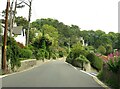
6

Beer : Townsend
Townsend heading through the town of Beer.
Image: © Lewis Clarke
Taken: 31 Dec 2017
0.08 miles
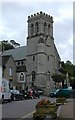
7
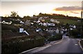
Beer: Main road around the Village
Image: © Mr Eugene Birchall
Taken: 2 Feb 2013
0.11 miles
9
Beer : Barnards Farm
A small cul-de-sac off of Causeway.
Image: © Lewis Clarke
Taken: 31 Dec 2017
0.12 miles
