IMAGES TAKEN NEAR TO
Park Road, SEATON, EX12 3HH
Introduction
This page details the photographs taken nearby to Park Road, EX12 3HH by members of the Geograph project.
The Geograph project started in 2005 with the aim of publishing, organising and preserving representative images for every square kilometre of Great Britain, Ireland and the Isle of Man.

There are currently over 7.5m images from over14,400 individuals and you can help contribute to the project by visiting https://www.geograph.org.uk
Image Map
Images are licensed for reuse under creativecommons.org/licenses/by-sa/2.0
Notes
- Clicking on the map will re-center to the selected point.
- The higher the marker number, the further away the image location is from the centre of the postcode.
Image Listing (84 Images Found)
Images are licensed for reuse under creativecommons.org/licenses/by-sa/2.0
Image
Details
Distance
6
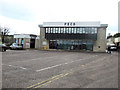
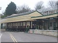
Pecorama main building and entrance
This is the headquarters of the Peco model railway company. Open as a tourist attraction with miniature railway and gardens
Image: © John Firth
Taken: 12 Apr 2013
0.11 miles
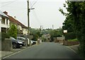
7
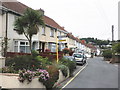
Underleys, Beer
Garages and houses on a road above the town centre. Traffic is signposted along here to avoid the narrow central streets.
Image: © Derek Harper
Taken: 29 May 2012
0.11 miles

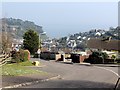
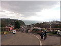
9
Pecorama Pleasure Gardens
Model railway and garden themed attraction on the edge of Beer.
Image: © John M
Taken: 25 Feb 2009
0.12 miles