IMAGES TAKEN NEAR TO
Branscombe, SEATON, EX12 3BW
Introduction
This page details the photographs taken nearby to EX12 3BW by members of the Geograph project.
The Geograph project started in 2005 with the aim of publishing, organising and preserving representative images for every square kilometre of Great Britain, Ireland and the Isle of Man.

There are currently over 7.5m images from over14,400 individuals and you can help contribute to the project by visiting https://www.geograph.org.uk
Image Map
Images are licensed for reuse under creativecommons.org/licenses/by-sa/2.0
Notes
- Clicking on the map will re-center to the selected point.
- The higher the marker number, the further away the image location is from the centre of the postcode.
Image Listing (1 Images Found)
Images are licensed for reuse under creativecommons.org/licenses/by-sa/2.0
Image
Details
Distance
1
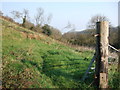
Below Edge Farm
This hillside is the northern slope of one of the two deep branches of the Branscombe valley network that cut into the plateau in this square, and is taken from a lane (not marked as a public road on the maps) that descends it from Edge Farm to Edge Barton.
Image: © Derek Harper
Taken: 2 Apr 2007
0.14 miles