IMAGES TAKEN NEAR TO
Branscombe, SEATON, EX12 3BL
Introduction
This page details the photographs taken nearby to EX12 3BL by members of the Geograph project.
The Geograph project started in 2005 with the aim of publishing, organising and preserving representative images for every square kilometre of Great Britain, Ireland and the Isle of Man.

There are currently over 7.5m images from over14,400 individuals and you can help contribute to the project by visiting https://www.geograph.org.uk
Image Map
Images are licensed for reuse under creativecommons.org/licenses/by-sa/2.0
Notes
- Clicking on the map will re-center to the selected point.
- The higher the marker number, the further away the image location is from the centre of the postcode.
Image Listing (4 Images Found)
Images are licensed for reuse under creativecommons.org/licenses/by-sa/2.0
Image
Details
Distance
2
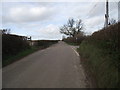
Footpath over the fields at Bulstone
Surprisingly dry at this time of year.
Image: © Anthony Vosper
Taken: 28 Nov 2011
0.23 miles
4
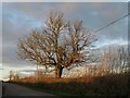
Tree by the lane to Branscombe Cross
Catching late sunshine on a winter afternoon. From the junction with the lane into Edge Farm.
Image: © Derek Harper
Taken: 11 Jan 2012
0.24 miles