IMAGES TAKEN NEAR TO
SEATON, EX12 3AA
Introduction
This page details the photographs taken nearby to EX12 3AA by members of the Geograph project.
The Geograph project started in 2005 with the aim of publishing, organising and preserving representative images for every square kilometre of Great Britain, Ireland and the Isle of Man.

There are currently over 7.5m images from over14,400 individuals and you can help contribute to the project by visiting https://www.geograph.org.uk
Image Map
Images are licensed for reuse under creativecommons.org/licenses/by-sa/2.0
Notes
- Clicking on the map will re-center to the selected point.
- The higher the marker number, the further away the image location is from the centre of the postcode.
Image Listing (10 Images Found)
Images are licensed for reuse under creativecommons.org/licenses/by-sa/2.0
Image
Details
Distance
1
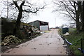
Ashdown Farm
Ashdown Farm sits right on the eastern edge of grid square SY2191 on a bend in the minor road from Gatcombe Ash on the A3052 to White gate on Colyton Hill.
Image: © Nigel Mykura
Taken: 29 Feb 2020
0.03 miles
2
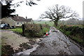
House at Ashdown Farm
This bungalow is very close to Ashdown Farm which sits in the adjacent grid square SY2191. The grid line between the two squares runs right through the house so that the front of the house (visible here) is in SY2291 but the rear of the house is in SY2191. The lane is the minor road from Gatcombe Ash on the A3052 to White Gate on Colyton Hill. There is a lot of debris on the road from recent storms.
Image: © Nigel Mykura
Taken: 29 Feb 2020
0.04 miles
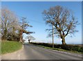
3
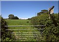
Towards Ashdown Farm
From the A3052 at Gatcombe Ash, with Ashdown Farm across a field of grass and thistles.
Image: © Derek Harper
Taken: 19 Jun 2012
0.10 miles
4
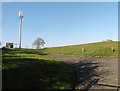
Reservoir and mobile phone mast at Gatcombe Ash
Image: © Roger Cornfoot
Taken: 23 Mar 2020
0.13 miles
5
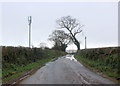
Gatcombe Ash
Gatcombe Ash is a cross roads on the A3052 just west of Seaton and is marked by a few trees a covered reservoir and a mobile phone mast.
Image: © Nigel Mykura
Taken: 29 Feb 2020
0.14 miles
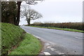
7
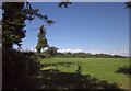
Grass field by the A3052
A view from the A3052, with trees along a field boundary. The wood in the valley of Holyford Goyle can be seen ahead.
Image: © Derek Harper
Taken: 19 Jun 2012
0.17 miles
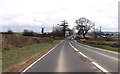
9
A 3052 at Gatcombe Ash
Gatcombe Ash is a cross roads on the A3052 just west of Seaton and is marked by a few trees a covered reservoir and a mobile phone mast.
Image: © Nigel Mykura
Taken: 29 Feb 2020
0.19 miles
10
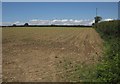
Crop near Ashdown Farm
Not sure what these little plants are. This is by the A3052.
Image: © Derek Harper
Taken: 19 Jun 2012
0.22 miles