IMAGES TAKEN NEAR TO
Buttercup Close, SEATON, EX12 2XB
Introduction
This page details the photographs taken nearby to Buttercup Close, EX12 2XB by members of the Geograph project.
The Geograph project started in 2005 with the aim of publishing, organising and preserving representative images for every square kilometre of Great Britain, Ireland and the Isle of Man.

There are currently over 7.5m images from over14,400 individuals and you can help contribute to the project by visiting https://www.geograph.org.uk
Image Map
Images are licensed for reuse under creativecommons.org/licenses/by-sa/2.0
Notes
- Clicking on the map will re-center to the selected point.
- The higher the marker number, the further away the image location is from the centre of the postcode.
Image Listing (12 Images Found)
Images are licensed for reuse under creativecommons.org/licenses/by-sa/2.0
Image
Details
Distance
1

The Hills above Seaton
Seaton, taken from the coast path using telephoto lens.
This is the west side of the Town
Image: © Raymond Cubberley
Taken: 21 Jun 2011
0.06 miles

3
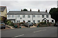
Rosedale Terrace, Colyford Road, Seaton
Row of 4 houses with a date plaque that reads 'Rosedale Terrace W.B.H. 1879'. No.2 'The Grockles Hide' is currently (2021 and probably since late 2019) available as a self catering holiday let.
Image: © Jo and Steve Turner
Taken: 23 Aug 2021
0.10 miles
4
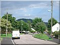
Elizabeth Road, Seaton
looking east, with Hawkesdown Hill in the background
Image: © Andrew Longton
Taken: 29 Jul 2005
0.11 miles

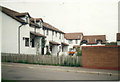

8

Gravel Lane, Seaton
The lane, on the left terminates after 200 yards and continues as a footpath which later joins Scalwell Lane.
Image: © Anthony Vosper
Taken: 23 Oct 2021
0.14 miles
9

Car Park on a Nature Reserve
This is the car park of the Black Hole Nature Reserve between Colyford and Seaton in Devon. Access is from Colyford Road and then through a small cemetery.
Image: © John P Reeves
Taken: 11 Jan 2023
0.15 miles
10

Boundary Close at the junction of Boundary Park
Image: © David Howard archives
Taken: Unknown
0.21 miles