IMAGES TAKEN NEAR TO
Highcliffe Close, SEATON, EX12 2QA
Introduction
This page details the photographs taken nearby to Highcliffe Close, EX12 2QA by members of the Geograph project.
The Geograph project started in 2005 with the aim of publishing, organising and preserving representative images for every square kilometre of Great Britain, Ireland and the Isle of Man.

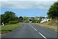
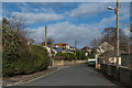
There are currently over 7.5m images from over14,400 individuals and you can help contribute to the project by visiting https://www.geograph.org.uk
Image Map
Images are licensed for reuse under creativecommons.org/licenses/by-sa/2.0
Notes
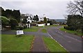
- Clicking on the map will re-center to the selected point.
- The higher the marker number, the further away the image location is from the centre of the postcode.
Image Listing (97 Images Found)
Images are licensed for reuse under creativecommons.org/licenses/by-sa/2.0
Image
Details
Distance
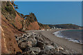
1
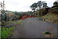
Landslip on the Old Beer Rd
The road is impassable at this point because a landslip has removed the full width of the road. This photo was taken through the fence which has been erected to prevent public access. It looks as if sewage pipes from local houses have had to be re-routed in the road.
Image: © Nigel Mykura
Taken: 21 Jan 2018
0.04 miles
2
Old Beer Road
Site of a major landslip on Old Beer Road which took place in 2014, taking out a section of the road.
Image: © Ian Capper
Taken: 8 Feb 2020
0.06 miles
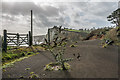
3
Old Beer Road
Metal fence across Old Beer Road, preventing access to the site of a major landslip which took place in 2014, taking out a section of the road - see Image
Image: © Ian Capper
Taken: 8 Feb 2020
0.06 miles
4
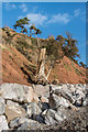
Landslip
The site of the 2014 landslip on Seaton Beach that took out a section of Old Beer Road.
Image: © Ian Capper
Taken: 8 Feb 2020
0.08 miles
5
B3174 Beer Road, Seaton
Leaving town for Beer.
Image: © Robin Webster
Taken: 20 Jul 2019
0.08 miles
6
Seaton : Beer Road
Beer Road heading down the hillside and into the town.
Image: © Lewis Clarke
Taken: 10 Mar 2013
0.08 miles
7
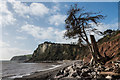
Landslip
The site of the 2014 landslip on Seaton Beach that took out a section of Old Beer Road. In the background is White Cliff with Beer Head beyond.
Image: © Ian Capper
Taken: 8 Feb 2020
0.08 miles
8
Landslip
The site of the 2014 landslip on Seaton Beach that took out a section of Old Beer Road. Seaton itself is in the background.
Image: © Ian Capper
Taken: 8 Feb 2020
0.08 miles
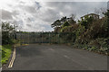
9
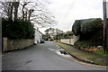
Old Beer Road
Looking along Old Beer Road, now a cul-de-sac following closure after a major landslip which took place in 2014, taking out a section of the road - see Image and Image
Image: © Ian Capper
Taken: 8 Feb 2020
0.09 miles
10
The Old Beer Rd
This road does not go much further than you can see as just round the next corner a landslip has removed the road.
Image: © Nigel Mykura
Taken: 21 Jan 2018
0.09 miles