IMAGES TAKEN NEAR TO
Potters Way, SEATON, EX12 2FZ
Introduction
This page details the photographs taken nearby to Potters Way, EX12 2FZ by members of the Geograph project.
The Geograph project started in 2005 with the aim of publishing, organising and preserving representative images for every square kilometre of Great Britain, Ireland and the Isle of Man.

There are currently over 7.5m images from over14,400 individuals and you can help contribute to the project by visiting https://www.geograph.org.uk
Image Map
Images are licensed for reuse under creativecommons.org/licenses/by-sa/2.0
Notes
- Clicking on the map will re-center to the selected point.
- The higher the marker number, the further away the image location is from the centre of the postcode.
Image Listing (6 Images Found)
Images are licensed for reuse under creativecommons.org/licenses/by-sa/2.0
Image
Details
Distance


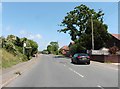
3

Barnards Hill Lane, Seaton
From the junction with Roman Way. Detached bungalows are the norm here.
Image: © Derek Harper
Taken: 15 Sep 2012
0.21 miles
4

Poplar Tree Drive, Seaton
Part of a modern housing estate on the northern edge of Seaton
Image: © David Smith
Taken: 11 Aug 2012
0.23 miles
5
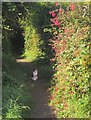
Cat on path, Roman Way, Seaton
A tortoiseshell-and-white cat watches me in perplexity from a path adjoining Roman Way. Some fuchsia in the hedge.
Image: © Derek Harper
Taken: 15 Sep 2012
0.23 miles