IMAGES TAKEN NEAR TO
Fortfield, SEATON, EX12 2AW
Introduction
This page details the photographs taken nearby to Fortfield, EX12 2AW by members of the Geograph project.
The Geograph project started in 2005 with the aim of publishing, organising and preserving representative images for every square kilometre of Great Britain, Ireland and the Isle of Man.

There are currently over 7.5m images from over14,400 individuals and you can help contribute to the project by visiting https://www.geograph.org.uk
Image Map
Images are licensed for reuse under creativecommons.org/licenses/by-sa/2.0
Notes
- Clicking on the map will re-center to the selected point.
- The higher the marker number, the further away the image location is from the centre of the postcode.
Image Listing (181 Images Found)
Images are licensed for reuse under creativecommons.org/licenses/by-sa/2.0
Image
Details
Distance
1

St Augustine's Presbytery - Manor Road
Image: © Betty Longbottom
Taken: 14 May 2018
0.08 miles
2

St Augustine's Catholic Church - Manor Road
Image: © Betty Longbottom
Taken: 14 May 2018
0.08 miles
3

Seaton Tramway Terminus
Southern end of the line from Seaton to Colyton.
Image: © Chris Coleman
Taken: Unknown
0.08 miles
4
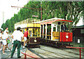
Trams at Seaton
Open topped double decker and open sided 'toastrack' type trams at Seaton
Image: © Chris Coleman
Taken: Unknown
0.08 miles

6
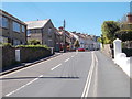
Manor Road - viewed from Fore Street
Image: © Betty Longbottom
Taken: 14 May 2018
0.10 miles
7
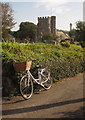
Bike and church, Seaton
The church is St Gregory's, http://www.britishlistedbuildings.co.uk/en-87581-church-of-st-gregory-seaton-devon ; "much pulled about", according to Cherry & Pevsner. The bike is outside the church hall. View from Seaton Footpath 3.
Image: © Derek Harper
Taken: 15 Sep 2012
0.11 miles
8
Church of St Gregory, Seaton
Across the churchyard from the road into Case Gardens. http://www.britishlistedbuildings.co.uk/en-87581-church-of-st-gregory-seaton-devon
View from Seaton Footpath 3.
Image: © Derek Harper
Taken: 15 Sep 2012
0.11 miles
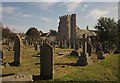
9
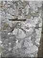
Ordnance Survey Cut Mark
This OS cut mark can be found on the SW angle of St Gregory's Church. It marks a point 10.5248m above mean sea level.
Image: © Adrian Dust
Taken: 27 Mar 2015
0.11 miles
10

Seaton, St. Gregory's Church: Southern aspect
Image: © Michael Garlick
Taken: 21 Jun 2022
0.11 miles