IMAGES TAKEN NEAR TO
Needlewood Close, OTTERY ST. MARY, EX11 1XR
Introduction
This page details the photographs taken nearby to Needlewood Close, EX11 1XR by members of the Geograph project.
The Geograph project started in 2005 with the aim of publishing, organising and preserving representative images for every square kilometre of Great Britain, Ireland and the Isle of Man.

There are currently over 7.5m images from over14,400 individuals and you can help contribute to the project by visiting https://www.geograph.org.uk
Image Map
Images are licensed for reuse under creativecommons.org/licenses/by-sa/2.0
Notes
- Clicking on the map will re-center to the selected point.
- The higher the marker number, the further away the image location is from the centre of the postcode.
Image Listing (8 Images Found)
Images are licensed for reuse under creativecommons.org/licenses/by-sa/2.0
Image
Details
Distance


3
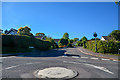
West Hill : Eastfield
Looking up Eastfield from a roundabout on West Hill Road.
Image: © Lewis Clarke
Taken: 13 May 2018
0.19 miles
4

West Hill : West Hill Road
At a roundabout from Higher Broad Oak Road.
Image: © Lewis Clarke
Taken: 13 May 2018
0.21 miles
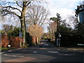
5

B3180 passing West Hill
The houses on the B3180 are the western edge of West Hill village
Image: © David Smith
Taken: 16 Mar 2011
0.21 miles

7
Main road into West Hill from the southwest
Image: © Rob Purvis
Taken: 24 Jan 2010
0.22 miles
