IMAGES TAKEN NEAR TO
Lower Broad Oak Road, OTTERY ST. MARY, EX11 1XH
Introduction
This page details the photographs taken nearby to Lower Broad Oak Road, EX11 1XH by members of the Geograph project.
The Geograph project started in 2005 with the aim of publishing, organising and preserving representative images for every square kilometre of Great Britain, Ireland and the Isle of Man.

There are currently over 7.5m images from over14,400 individuals and you can help contribute to the project by visiting https://www.geograph.org.uk
Image Map
Images are licensed for reuse under creativecommons.org/licenses/by-sa/2.0
Notes
- Clicking on the map will re-center to the selected point.
- The higher the marker number, the further away the image location is from the centre of the postcode.
Image Listing (5 Images Found)
Images are licensed for reuse under creativecommons.org/licenses/by-sa/2.0
Image
Details
Distance
1
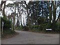
Hawkins Lane
This private road is also a public bridleway
Image: © David Smith
Taken: 15 Apr 2012
0.15 miles
2
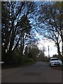
Road through Broad Oak Bottom in West Hill
Image: © David Smith
Taken: 15 Apr 2012
0.17 miles
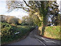
4

Lower Broad Oak Road, West Hill
Leafy suburbia in the midst of rural Devon. Seen from the junction with Ford Lane.
Image: © Derek Harper
Taken: 3 May 2006
0.18 miles
5
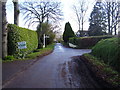
Junction at Broad Oak,West Hill
The two communities are described as a woodland village.
Image: © Anthony Vosper
Taken: 1 Feb 2014
0.21 miles