IMAGES TAKEN NEAR TO
Lower Broad Oak Road, OTTERY ST. MARY, EX11 1UF
Introduction
This page details the photographs taken nearby to Lower Broad Oak Road, EX11 1UF by members of the Geograph project.
The Geograph project started in 2005 with the aim of publishing, organising and preserving representative images for every square kilometre of Great Britain, Ireland and the Isle of Man.

There are currently over 7.5m images from over14,400 individuals and you can help contribute to the project by visiting https://www.geograph.org.uk
Image Map
Images are licensed for reuse under creativecommons.org/licenses/by-sa/2.0
Notes
- Clicking on the map will re-center to the selected point.
- The higher the marker number, the further away the image location is from the centre of the postcode.
Image Listing (14 Images Found)
Images are licensed for reuse under creativecommons.org/licenses/by-sa/2.0
Image
Details
Distance
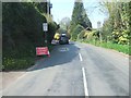
2

West Hill : Castle Farm
Looking along a small lane heading through West Hill.
Image: © Lewis Clarke
Taken: 14 Mar 2018
0.02 miles
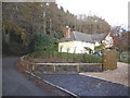
4

West Hill : Lower Broad Oak Road
Looking along a driveway on Lower Broad Oak Road.
Image: © Lewis Clarke
Taken: 14 Mar 2018
0.04 miles

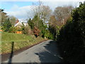
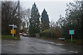
6

West Hill : Lower Broad Oak Road
Looking along a small road through West Hill.
Image: © Lewis Clarke
Taken: 14 Mar 2018
0.06 miles
8

West Hill : School Lane
Looking along School Lane in West Hill.
Image: © Lewis Clarke
Taken: 14 Mar 2018
0.20 miles
9
West Hill : Bendarroch Road
Looking along Bendarroch Road in West Hill.
Image: © Lewis Clarke
Taken: 14 Mar 2018
0.21 miles