IMAGES TAKEN NEAR TO
Higher Metcombe, OTTERY ST. MARY, EX11 1SH
Introduction
This page details the photographs taken nearby to EX11 1SH by members of the Geograph project.
The Geograph project started in 2005 with the aim of publishing, organising and preserving representative images for every square kilometre of Great Britain, Ireland and the Isle of Man.

There are currently over 7.5m images from over14,400 individuals and you can help contribute to the project by visiting https://www.geograph.org.uk
Image Map
Images are licensed for reuse under creativecommons.org/licenses/by-sa/2.0
Notes
- Clicking on the map will re-center to the selected point.
- The higher the marker number, the further away the image location is from the centre of the postcode.
Image Listing (10 Images Found)
Images are licensed for reuse under creativecommons.org/licenses/by-sa/2.0
Image
Details
Distance
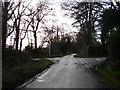
1
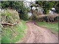
Higher Metcombe track
Track leading from Higher Metcombe to Fluxton in early Spring
Image: © Roger Rowe
Taken: 25 Feb 2005
0.02 miles
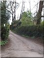
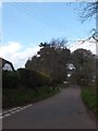
2

East Devon : Higher Broad Oak Road
A road heading towards West Hill.
Image: © Lewis Clarke
Taken: 13 May 2018
0.12 miles
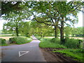
3
Track and footpath in Higher Metcombe
The track leads to several houses and a plant nursery
Image: © David Smith
Taken: 15 Apr 2012
0.13 miles
4
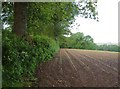
Edge of field, Heathlands Cross
The view over the gate on the left of Image
Image: © Derek Harper
Taken: 30 May 2006
0.17 miles
5
Broad Oak Cross
Most of the district is known as Broad Oak (two words) but the upright of the sign runs the two together.
Image: © David Smith
Taken: 15 Apr 2012
0.17 miles
8
Heathlands Cross
A junction of lanes just to the south of West Hill; looking west towards Tipton Cross along Oak Road. NCN52 runs across the main lane here.
Image: © Derek Harper
Taken: 30 May 2006
0.19 miles

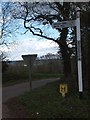
10

You are now entering West Hill
The sign describes the area as a Woodland Community.
Image: © Anthony Vosper
Taken: 1 Feb 2014
0.21 miles