IMAGES TAKEN NEAR TO
Batts Lane, OTTERY ST. MARY, EX11 1EY
Introduction
This page details the photographs taken nearby to Batts Lane, EX11 1EY by members of the Geograph project.
The Geograph project started in 2005 with the aim of publishing, organising and preserving representative images for every square kilometre of Great Britain, Ireland and the Isle of Man.

There are currently over 7.5m images from over14,400 individuals and you can help contribute to the project by visiting https://www.geograph.org.uk
Image Map (Loading...)


Getting Data...Please wait
Leaflet Map data © OpenStreetMap
Images are licensed for reuse under creativecommons.org/licenses/by-sa/2.0
Notes
- Clicking on the map will re-center to the selected point.
- The higher the marker number, the further away the image location is from the centre of the postcode.
Image Listing (216 Images Found)
Images are licensed for reuse under creativecommons.org/licenses/by-sa/2.0
Image
Details
Distance
1

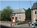
Ottery St Mary old fire station
Ottery St Mary old fire station, Brook Street, Ottery St Mary, Devon, which was replaced by the new station Image
Image: © Kevin Hale
Taken: 29 Jun 2006
0.01 miles
2

Remains of old chapel, Batt's Lane, Ottery St. Mary
Image: © Jonathan Thacker
Taken: 18 Sep 2018
0.02 miles
3

Former school, Sandhill Street, Ottery St. Mary
Image: © Jonathan Thacker
Taken: 18 Sep 2018
0.03 miles
4
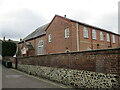
Congregational church, Ottery St. Mary
The older part (left) dates from 1688 https://historicengland.org.uk/listing/the-list/list-entry/1213322
Image: © Jonathan Thacker
Taken: 18 Sep 2018
0.03 miles
5
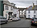
Cornhill, Ottery St. Mary, Devon
Looking South down Cornhill to the Tee junction where Sandhill Street goes to the left, and Gold Street to the right. The Kings Arms Hotel is situated at the point where all three meet.
Image: © Derek Voller
Taken: 13 Sep 2013
0.03 miles
6
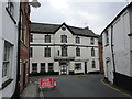
The Kings Arms, Gold Street, Ottery St. Mary
An eighteenth century inn facing up Cornhill.
Image: © Jonathan Thacker
Taken: 18 Sep 2018
0.03 miles
7
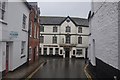
Ottery St Mary : Corn Hill & The King's Arms
Looking towards the Kings Arms at the junction with Gold Street.
Image: © Lewis Clarke
Taken: 7 Jul 2012
0.04 miles
8
United Reformed Church
The URC in Ottery was built in 1688 and is one of the oldest non-conformist churches in England.
Image: © David Smith
Taken: 18 Apr 2011
0.04 miles
9

The Normandy House, Ottery St Mary
A hotel and restaurant in a Grade II-listed building that dates back to 1760
Image: © Chris Holifield
Taken: 28 Oct 2013
0.04 miles
10

B3174, Ottery St Mary
In the foreground this is Jesu Street; at the junction on the left with Batt's Lane, it becomes Yonder Street. By the time it reaches the gabled Institute on the left, the B road has crossed into Image
Image: © Derek Harper
Taken: 3 Sep 2012
0.04 miles