IMAGES TAKEN NEAR TO
South Lawn, SIDMOUTH, EX10 9PD
Introduction
This page details the photographs taken nearby to South Lawn, EX10 9PD by members of the Geograph project.
The Geograph project started in 2005 with the aim of publishing, organising and preserving representative images for every square kilometre of Great Britain, Ireland and the Isle of Man.

There are currently over 7.5m images from over14,400 individuals and you can help contribute to the project by visiting https://www.geograph.org.uk
Image Map
Images are licensed for reuse under creativecommons.org/licenses/by-sa/2.0
Notes
- Clicking on the map will re-center to the selected point.
- The higher the marker number, the further away the image location is from the centre of the postcode.
Image Listing (114 Images Found)
Images are licensed for reuse under creativecommons.org/licenses/by-sa/2.0
Image
Details
Distance
1
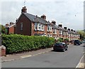
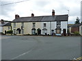
Long row of houses, South Lawn, Sidford
Viewed from Sidford Road. The row of 15 houses extends for 70 metres on the north side of South Lawn.
Image: © Jaggery
Taken: 18 Jun 2013
0.02 miles
2

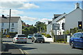
A3052 junction ahead, Sidford
Viewed along the A375 Sidford Road. South Lawn houses http://www.geograph.org.uk/photo/3548330 are on the right.
At the junction 90 metres ahead, turn left for Exeter, right for Lyme Regis and Seaton,
or right then left for Honiton.
Image: © Jaggery
Taken: 18 Jun 2013
0.03 miles
3
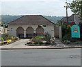
Public toilets, Sidford
Viewed from Sidford High Street. The Sidmouth boundary sign is on the right.
Image: © Jaggery
Taken: 18 Jun 2013
0.04 miles
4

Welcome to Sidmouth
Situated on the Sidford crossroads.
The view on the sign is of an archway in the Connaught Gardens SY1286.
Image: © Anthony Vosper
Taken: 11 Sep 2009
0.04 miles
5
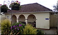
Public toilets with sheltered benches, Sidford
Image: © David Smith
Taken: 26 Jun 2017
0.04 miles
6
Nos 1 - 4, Church Street, Sidford
Also known as Albert House, and Orchard Terrace, this row of 4 cottages dates from about 1850, and was given a Grade II listing https://www.britishlistedbuildings.co.uk/101097988-albert-houseorchard-terrace-sidmouth#.WYAhI4QrKM8 in 1973.
Image: © Richard Law
Taken: 16 Jul 2017
0.05 miles
7

The Cabin, Sidford
Located in Church Street, The Cabin is a wood and brick hut measuring about 15ft by 10ft.
The former fish and grocery store was converted to a tiny house c2000.
Image: © Jaggery
Taken: 18 Jun 2013
0.05 miles
8

Ordnance Survey Flush Bracket (2087)
This OS Flush Bracket can be found on the east face of Cornerways Cottage. It marks a point 42.4724m above mean sea level.
Image: © Adrian Dust
Taken: 27 Mar 2015
0.05 miles
9
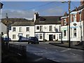
The Rising Sun inn, Sidford
The inn is at the crossroads in the centre of the village
Image: © David Smith
Taken: 15 Jan 2016
0.05 miles