IMAGES TAKEN NEAR TO
Primley Road, SIDMOUTH, EX10 9LG
Introduction
This page details the photographs taken nearby to Primley Road, EX10 9LG by members of the Geograph project.
The Geograph project started in 2005 with the aim of publishing, organising and preserving representative images for every square kilometre of Great Britain, Ireland and the Isle of Man.

There are currently over 7.5m images from over14,400 individuals and you can help contribute to the project by visiting https://www.geograph.org.uk
Image Map
Images are licensed for reuse under creativecommons.org/licenses/by-sa/2.0
Notes
- Clicking on the map will re-center to the selected point.
- The higher the marker number, the further away the image location is from the centre of the postcode.
Image Listing (28 Images Found)
Images are licensed for reuse under creativecommons.org/licenses/by-sa/2.0
Image
Details
Distance
1

Hill Lane, Sidmouth
Despite its name, this is a footpath only.
Image: © David Purchase
Taken: 24 Apr 2015
0.07 miles
2

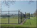
Sidmouth College sports area
Viewed from the footpath and cycleway from Sidford to Fortescue and Sidmouth seafront.
Image: © Jaggery
Taken: 18 Jun 2013
0.08 miles
3

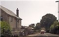
Malden Road, Sidmouth
Houses on the north side of Malden Road, viewed from the Sidford Road end.
Image: © Jaggery
Taken: 18 Jun 2013
0.09 miles

5
Sports courts and Sidmouth College
Seen from The Byes Path that links Sidmouth with Sidford.
Image: © Chris Allen
Taken: 17 Apr 2019
0.14 miles
6

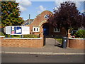
Malden House, Sidmouth
Residential care home with 19 bedrooms, located at 69 Sidford Road.
Image: © Jaggery
Taken: 18 Jun 2013
0.15 miles
7
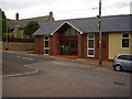
Primley Road Church
Built originally as a United Reformed Church.
Image: © Anthony Vosper
Taken: 25 Sep 2009
0.16 miles
9

Footpath signs west of Fortescue
The signs are alongside a footpath and cycleway from Sidford (½ mile behind the camera)
to Sidmouth seafront (1¾ miles ahead). The path heading left (east) is for Fortescue (¼ mile).
Image: © Jaggery
Taken: 18 Jun 2013
0.17 miles
10
Emmanuel Baptist church, Manstone.
Built to serve the local estate. The building in the background is Manston Old House dating back to 1589.
Image: © Anthony Vosper
Taken: 31 Aug 2009
0.18 miles