IMAGES TAKEN NEAR TO
Heritage Way, SIDMOUTH, EX10 9JY
Introduction
This page details the photographs taken nearby to Heritage Way, EX10 9JY by members of the Geograph project.
The Geograph project started in 2005 with the aim of publishing, organising and preserving representative images for every square kilometre of Great Britain, Ireland and the Isle of Man.

There are currently over 7.5m images from over14,400 individuals and you can help contribute to the project by visiting https://www.geograph.org.uk
Image Map
Images are licensed for reuse under creativecommons.org/licenses/by-sa/2.0
Notes
- Clicking on the map will re-center to the selected point.
- The higher the marker number, the further away the image location is from the centre of the postcode.
Image Listing (25 Images Found)
Images are licensed for reuse under creativecommons.org/licenses/by-sa/2.0
Image
Details
Distance
1

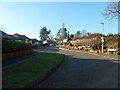
Heritage Way, Sidmouth
Housing developments on the north side of Sidmouth.
Image: © Richard Law
Taken: 15 Jul 2017
0.03 miles
2

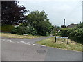
Manstone lane
A sharp turn to a one way system off the busy A3052.
Image: © Anthony Vosper
Taken: 4 Jan 2022
0.04 miles
3

Burscombe Lane Junction. Island.
Choose any number of permutations, Bus stop, Post box, sign or bench.All contained on an island in the middle of the road junction.
Soldiers hill is in the background.
Image: © Anthony Vosper
Taken: 15 Sep 2009
0.06 miles
4

Burscombe Lane junction
A good example of urban regeneration. The new apartments in the background replaced a pre war house.
Image: © Anthony Vosper
Taken: 15 Sep 2009
0.06 miles
5
Coombe Hayes
A quiet corner of Manstone, Sidmouth.
Image: © Anthony Vosper
Taken: 24 Jan 2023
0.07 miles

7

King Charles' Way, Sidmouth
Housing on the north side of Sidmouth.
Image: © Richard Law
Taken: 15 Jul 2017
0.10 miles
8

OS benchmark - Sidford, Burscombe Lane
An OS cutmark on a stone wall at the junction of Burscombe Lane with Back Lane. It was originally levelled, probably in 1967, at 87.609m above Ordnance Datum Newlyn.
Image: © Richard Law
Taken: 15 Jul 2017
0.11 miles
9

Newlands Close, Sidmouth
A residential area with lovely views down the Sid Vale
Image: © David Stowell
Taken: 1 May 2005
0.16 miles
10
Corner of Manstone Mead and Malden Lane, Sidmouth
Viewed from Manstone Lane.
Image: © Jaggery
Taken: 18 Jun 2013
0.17 miles