IMAGES TAKEN NEAR TO
Alexandria Industrial Estate, Alexandria Road, SIDMOUTH, EX10 9HL
Introduction
This page details the photographs taken nearby to Alexandria Industrial Estate, Alexandria Road, EX10 9HL by members of the Geograph project.
The Geograph project started in 2005 with the aim of publishing, organising and preserving representative images for every square kilometre of Great Britain, Ireland and the Isle of Man.

There are currently over 7.5m images from over14,400 individuals and you can help contribute to the project by visiting https://www.geograph.org.uk
Image Map
Images are licensed for reuse under creativecommons.org/licenses/by-sa/2.0
Notes
- Clicking on the map will re-center to the selected point.
- The higher the marker number, the further away the image location is from the centre of the postcode.
Image Listing (62 Images Found)
Images are licensed for reuse under creativecommons.org/licenses/by-sa/2.0
Image
Details
Distance
1

Footpath, Sidmouth
A reverse view of Image This is Sidmouth Footpath 162.
Image: © Derek Harper
Taken: 9 Sep 2016
0.05 miles
2

Pathwhorlands egg rolling
A family tradition started over 20 years ago.
Originally for just the photographers children.
This year over 50 people attended. Family,friends and neighbours.
Image: © Anthony Vosper
Taken: 14 Apr 2017
0.06 miles
3

Pathwhorlands
The only place with the name in the UK.
Early maps refer to it as Worlands orchard.
This is the photographer's 3,000 photograph submitted to this site.
It is also his home turf and grid square.
Image: © Anthony Vosper
Taken: 2 Nov 2022
0.06 miles
4
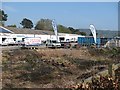
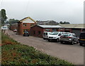
Fords self storage
A storage business on former railway land in Lower Woolbrook on the edge of Sidmouth.
Image: © Richard Webb
Taken: 19 Apr 2011
0.06 miles
5
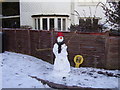
The guardian of the fire hydrant
Please Dad put my snowman on the net.
Image: © Anthony Vosper
Taken: 7 Jan 2010
0.06 miles
6

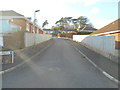
Pines above the path. Sidmouth
Above Sidmouth Footpath 162 as it approaches Balfours.
Image: © Derek Harper
Taken: 9 Sep 2016
0.07 miles
7
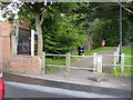
Pathwhorlands, Balfours footpath
This footpath was opened in 1999 as a result of resident pressure to have a safe route avoiding nearby Alexandria road which had no pavement.The object to the left is part of the remains of the former gas works.
Image: © Anthony Vosper
Taken: 28 Aug 2009
0.07 miles
8
Balfour Gardens
A late 20th Century development.
Just visible below the trees is the apex to a house.
This and two others were built on the site of the reservoir, which is currently still marked on the map.
Image: © Anthony Vosper
Taken: 5 Feb 2018
0.08 miles
9
Station Yard businesses, Sidmouth
A view from Station Road of some of the businesses occupying the former Sidmouth railway station, which closed in 1967.
Image: © Jaggery
Taken: 18 Jun 2013
0.09 miles
10
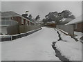
Welcome Storm Emma
Balfour Gardens carpeted in snow.
Image will give you a view without the snow.
Image: © Anthony Vosper
Taken: 2 Mar 2018
0.09 miles