IMAGES TAKEN NEAR TO
Ridgeway Mead, SIDMOUTH, EX10 9DT
Introduction
This page details the photographs taken nearby to Ridgeway Mead, EX10 9DT by members of the Geograph project.
The Geograph project started in 2005 with the aim of publishing, organising and preserving representative images for every square kilometre of Great Britain, Ireland and the Isle of Man.

There are currently over 7.5m images from over14,400 individuals and you can help contribute to the project by visiting https://www.geograph.org.uk
Image Map
Images are licensed for reuse under creativecommons.org/licenses/by-sa/2.0
Notes
- Clicking on the map will re-center to the selected point.
- The higher the marker number, the further away the image location is from the centre of the postcode.
Image Listing (38 Images Found)
Images are licensed for reuse under creativecommons.org/licenses/by-sa/2.0
Image
Details
Distance
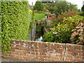
1
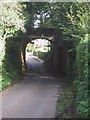
Bridge on old railway line crosses road
Image: © Sarah Charlesworth
Taken: 10 Oct 2008
0.06 miles
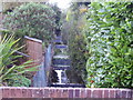
2
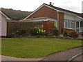
Quietly does it
A discrete sign in Higher Woolbrook Park points to a path that will give access to the old railway line and the Folk Week camp site.
Image: © Anthony Vosper
Taken: 2 Oct 2009
0.08 miles
3
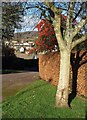
Colour on Bennetts Hill, Sidmouth
Red berries overhang a beech hedge. The map indicates that Sidmouth Footpath 16 ends here; its presence probably explains the wide verge which also finishes at this corner.
Image: © Derek Harper
Taken: 11 Jan 2012
0.09 miles
4

Bennetts Hill, Sidmouth
A fine show of berries on the grass verge where Woolbrook Park gives way to Bennetts Hill.
Image: © Derek Harper
Taken: 11 Jan 2012
0.10 miles
5

Derelict farm buildings in Dark Lane, Sidmouth
Only recently exposed having been completely overgrown.
Image: © Anthony Vosper
Taken: 7 Dec 2011
0.10 miles
6
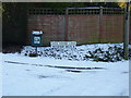
A cold place
Ice House Lane, Woolbrook on this occasion lives up to its name.
The original ice house has long since gone.
Image: © Anthony Vosper
Taken: 7 Jan 2010
0.11 miles
7
Looking down stream
The Wool Brook makes its way between the backs of houses at Woolbrook.
Image: © Anthony Vosper
Taken: 2 Oct 2009
0.11 miles
8
Looking up stream
The Wool Brook makes its way gently behind the houses at Higher Woolbrook Park.
Image: © Anthony Vosper
Taken: 2 Oct 2009
0.13 miles
9
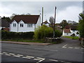
Junction of Woolbrook Road and Ice House Lane
A grade II Listed Building, an old thatched barn originally stood on the site of the white house.
Image: © Anthony Vosper
Taken: 17 Apr 2012
0.13 miles
10
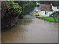
Sidmouth floods (5)
Ice House Lane 7.30 in the morning. For weather watchers this spot is a frost hollow, but not today.
There is a picture of this location in the snow on this page.
Image: © Anthony Vosper
Taken: 7 Jul 2012
0.13 miles