
IMAGES TAKEN NEAR TO
Salters Meadow, SIDMOUTH, EX10 9BL
Introduction
This page details the photographs taken nearby to Salters Meadow, EX10 9BL by members of the Geograph project.
The Geograph project started in 2005 with the aim of publishing, organising and preserving representative images for every square kilometre of Great Britain, Ireland and the Isle of Man.

There are currently over 7.5m images from over14,400 individuals and you can help contribute to the project by visiting https://www.geograph.org.uk
Image Map
Images are licensed for reuse under creativecommons.org/licenses/by-sa/2.0
Notes
- Clicking on the map will re-center to the selected point.
- The higher the marker number, the further away the image location is from the centre of the postcode.
Image Listing (132 Images Found)
Images are licensed for reuse under creativecommons.org/licenses/by-sa/2.0
Image
Details
Distance
1

Autumn gold
Trees in the Byes.
The pine tree was later decorated as a "celebration" of the pandemic.
Image: © Anthony Vosper
Taken: 6 Nov 2020
0.02 miles
2

Weir on the Sid
Trees reflected in the river, seen from The Byes, through which runs Sidmouth Footpath 10.
Image: © Derek Harper
Taken: 11 Jan 2012
0.04 miles
3
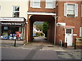
Entrance to the former Express Dairy, Temple Street
Now infilled with houses. This was once the home to up to 12 milk floats.
Deliveries had to be reversed in as there was no room to turn at the bottom.
Image: © Anthony Vosper
Taken: 19 Sep 2009
0.05 miles
4

Butcher's shop, Temple Street
The shopfront has a tiled picture of a bull. There is some finely detailed brickwork just below the soffits.
Image: © David Smith
Taken: 25 Nov 2010
0.05 miles
5

Detail of Butcher's shop, Temple Street
The shop is shown in Image
Image: © David Smith
Taken: 25 Nov 2010
0.05 miles
6

River Sid downstream from a footbridge near Sid Park Road, Sidmouth
Viewed from this http://www.geograph.org.uk/photo/3676454 wooden footbridge.
The Sid is a short river in East Devon, 10½ km (c 6½ miles) long.
Image: © Jaggery
Taken: 18 Jun 2013
0.06 miles
7

Temple Street, Sidmouth
Terraced houses along the A375, by the junction with Salters Meadow.
Image: © Derek Harper
Taken: 9 Sep 2016
0.06 miles
8

All change
The D.I.Y shop has been converted into a private dwelling and the newsagents in to a hair saloon.
The previously photographed cigarette machine has also gone.
Image: © Anthony Vosper
Taken: 26 Dec 2010
0.06 miles
9
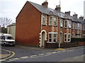
Salters Meadow junction with Temple Street
An Edwardian row of terraced houses.
The corner house which is the location for an OS Bench Mark, is called Yoruba. Which according to Wikipedia is named after a West African ethnic group.
But why?
Image: © Anthony Vosper
Taken: 4 Apr 2014
0.06 miles
10
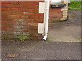
An OS Bench Mark
Situated on a wall in Salters Meadow on the junction with Temple Street.
Image: © Anthony Vosper
Taken: 4 Apr 2014
0.06 miles