IMAGES TAKEN NEAR TO
Brewery Lane, SIDMOUTH, EX10 8UW
Introduction
This page details the photographs taken nearby to Brewery Lane, EX10 8UW by members of the Geograph project.
The Geograph project started in 2005 with the aim of publishing, organising and preserving representative images for every square kilometre of Great Britain, Ireland and the Isle of Man.

There are currently over 7.5m images from over14,400 individuals and you can help contribute to the project by visiting https://www.geograph.org.uk
Image Map
Images are licensed for reuse under creativecommons.org/licenses/by-sa/2.0
Notes
- Clicking on the map will re-center to the selected point.
- The higher the marker number, the further away the image location is from the centre of the postcode.
Image Listing (151 Images Found)
Images are licensed for reuse under creativecommons.org/licenses/by-sa/2.0
Image
Details
Distance
1
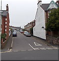
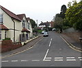
Peaslands Road, Sidmouth
Peaslands Road climbs westwards away from Temple Street.
Image: © Jaggery
Taken: 18 Jun 2013
0.02 miles
2
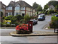
Post Box Peaslands road
This really is in the middle of the road. You can even sit on the bench and wait for the Postman. Situated on the junction of Peasland Road and Brewery lane.
Image: © Anthony Vosper
Taken: 28 Aug 2009
0.02 miles
3
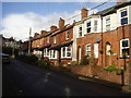
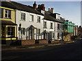
Sidholme Cottages,Brewery Lane
Note the distinct divide in the row of late Victorian houses.
An indication that the row was either built in two stages or by two different builders.
Image: © Anthony Vosper
Taken: 12 Jan 2016
0.06 miles

5
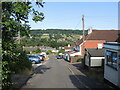
Ascerton Road
A steep one but with a view over the Sid Vale, and located in the Land Part district of Sidmouth.
Image: © Neil Owen
Taken: 16 Jun 2023
0.10 miles
6

Different signs on one house
Sidmouth has a varied approach to civic signage.
Image: © Neil Owen
Taken: 16 Jun 2023
0.11 miles
7
Ascerton Road Sidmouth
Looking west along Ascerton Road from Temple Street.
Image: © Jaggery
Taken: 18 Jun 2013
0.11 miles
8
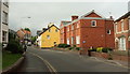
50 Temple Street
One of a number of listed buildings in the area.
Image: © Anthony Vosper
Taken: 12 Dec 2011
0.11 miles
9
Police station, Sidmouth
Also shown in Image] and Image, and succeeded by the junction with Woolcombe Lane. It dates from 1911. The ochre-coloured house on the corner is described at https://www.historicengland.org.uk/listing/the-list/list-entry/1228254 ; see also Image The main road is Temple Street, the A375.
Image: © Derek Harper
Taken: 9 Sep 2016
0.11 miles
10

Police station, Sidmouth
Also seen in Image The brick building, designed by E H Herbottle & Son, dates from 1911.
Image: © Derek Harper
Taken: 9 Sep 2016
0.11 miles