IMAGES TAKEN NEAR TO
Sidlands, SIDMOUTH, EX10 8UE
Introduction
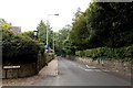
This page details the photographs taken nearby to Sidlands, EX10 8UE by members of the Geograph project.
The Geograph project started in 2005 with the aim of publishing, organising and preserving representative images for every square kilometre of Great Britain, Ireland and the Isle of Man.

There are currently over 7.5m images from over14,400 individuals and you can help contribute to the project by visiting https://www.geograph.org.uk
Image Map
Images are licensed for reuse under creativecommons.org/licenses/by-sa/2.0
Notes
- Clicking on the map will re-center to the selected point.
- The higher the marker number, the further away the image location is from the centre of the postcode.
Image Listing (195 Images Found)
Images are licensed for reuse under creativecommons.org/licenses/by-sa/2.0
Image
Details
Distance
1

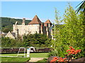
Powys House
A Grade II listed building.
Converted into flats. Linked to a modern block by a glass conservatory.
Image: © Anthony Vosper
Taken: 4 May 2021
0.06 miles
2
Where does this go?
Answer: Nowhere. An almost blocked up gateway in Station Road.
Image: © Anthony Vosper
Taken: 1 Mar 2014
0.06 miles
3
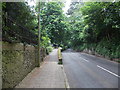
Elevated pavement, Station Road, Sidmouth
The pavement is raised above road level ahead, through a leafy section of Station Road with a rural appearance.
Image: © Jaggery
Taken: 18 Jun 2013
0.07 miles
4
Sidmouth Pretence
This building shows styles from many different periods. It is all a pretence...
Image: © Ian James Cox
Taken: 17 Sep 2009
0.07 miles
5
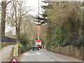
Now that's one big crane
Tree felling in Station Road Sidmouth.
Image: © Anthony Vosper
Taken: 19 Mar 2021
0.07 miles
6
Station Road north of Knowle Drive, Sidmouth
The section of Station Road ahead has a rural appearance despite being within the town.
Image: © Jaggery
Taken: 18 Jun 2013
0.07 miles
7

Sidmouth Regency Buildings
Sidmouth is a Regency Period town with many buildings erected during that time showing a mixture of Georgian and Gothic influences. This is a fine example.
Image: © Ian James Cox
Taken: 17 Sep 2009
0.07 miles
8

Path alongside Station Road, Sidmouth
With a park between the road and the council offices on the left.
Image: © Derek Harper
Taken: 11 Jan 2012
0.09 miles
9

Knowle Drive Bench Mark and rivet
A cut OS Bench Mark on a wall close to a road junction.
The arrow points to a survey rivet.
Image: © Anthony Vosper
Taken: 4 Jun 2014
0.09 miles
10
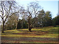
Winter trees.The Knowle
Sweet Chestnut and London Plain. In the grounds of the local council offices.
The area adjacent to the trees was once a natural arena for the Sidmouth Folk Festival.
Image: © Anthony Vosper
Taken: 8 Feb 2015
0.09 miles