IMAGES TAKEN NEAR TO
Cotmaton Road, SIDMOUTH, EX10 8SS
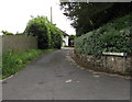
Introduction
This page details the photographs taken nearby to Cotmaton Road, EX10 8SS by members of the Geograph project.
The Geograph project started in 2005 with the aim of publishing, organising and preserving representative images for every square kilometre of Great Britain, Ireland and the Isle of Man.

There are currently over 7.5m images from over14,400 individuals and you can help contribute to the project by visiting https://www.geograph.org.uk
Image Map
Images are licensed for reuse under creativecommons.org/licenses/by-sa/2.0
Notes
- Clicking on the map will re-center to the selected point.
- The higher the marker number, the further away the image location is from the centre of the postcode.
Image Listing (143 Images Found)
Images are licensed for reuse under creativecommons.org/licenses/by-sa/2.0
Image
Details
Distance
1
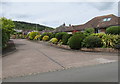
Cotlands, Cotmaton, Sidmouth
Cotlands is an area of houses on the west side of Cotmaton Road.
Image: © Jaggery
Taken: 18 May 2017
0.05 miles
2

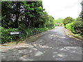
Cunninghams Lane
Local footpath No6. This well maintained path links Cotmaton Road to Manor Road.
Image: © Anthony Vosper
Taken: 15 Jan 2010
0.05 miles
3
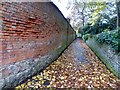
Cunningham's Lane, Cotmaton, Sidmouth
A brick wall on a stone foundation on one side of this footpath
Image: © David Smith
Taken: 4 Nov 2015
0.06 miles
4

View Towards Sidmouth
View west from Peak Hill over the town. There is a steep road down into the town from here . The closest part of the town in the middle of the image is Cotmaton.
Image: © Nigel Mykura
Taken: 21 Feb 2016
0.09 miles
5
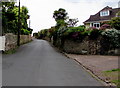
Up Cotmaton Road, Cotmaton, Sidmouth
Cotmaton Road ascends past the corner of Boughmore Lane on the right. Ahead for Peak Hill Road.
Image: © Jaggery
Taken: 18 May 2017
0.11 miles
6

Block of flats, Witheby, Cotmaton
In Cotmaton, just west of Sidmouth
Image: © David Smith
Taken: 4 Nov 2015
0.11 miles
7
Moorcourt Close, Sidmouth
Dead-end road viewed across Cotmaton Road.
Image: © Jaggery
Taken: 18 May 2017
0.11 miles
8
The Marino, Cotmaton, Sidmouth
Cul-de-sac on the southeast side of Cotmaton Road, opposite Marino Lodge. http://www.geograph.org.uk/photo/5397246
Image: © Jaggery
Taken: 18 May 2017
0.12 miles
9

Marino Lodge, Cotmaton Road, Sidmouth
The early 19th century thatched cottage was Grade II listed in 1951 (as Pauntley Cottage).
Image: © Jaggery
Taken: 18 May 2017
0.13 miles
10

Leafy Cotmaton Road, Sidmouth
Looking to the northeast along Cotmaton Road in May 2017.
Image: © Jaggery
Taken: 18 May 2017
0.14 miles