IMAGES TAKEN NEAR TO
Convent Road, SIDMOUTH, EX10 8RL
Introduction
This page details the photographs taken nearby to Convent Road, EX10 8RL by members of the Geograph project.
The Geograph project started in 2005 with the aim of publishing, organising and preserving representative images for every square kilometre of Great Britain, Ireland and the Isle of Man.

There are currently over 7.5m images from over14,400 individuals and you can help contribute to the project by visiting https://www.geograph.org.uk
Image Map
Images are licensed for reuse under creativecommons.org/licenses/by-sa/2.0
Notes
- Clicking on the map will re-center to the selected point.
- The higher the marker number, the further away the image location is from the centre of the postcode.
Image Listing (98 Images Found)
Images are licensed for reuse under creativecommons.org/licenses/by-sa/2.0
Image
Details
Distance
1
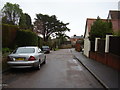
The road divides
Convent Road branches right whilst Cheese Lane carries straight on.
Image: © Anthony Vosper
Taken: 7 Jan 2011
0.02 miles
2

Cars parked in Bickwell Valley, Sidmouth
This is the southeast end of the road named Bickwell Valley, viewed from the corner of Cotmaton Road.
Image: © Jaggery
Taken: 18 May 2017
0.06 miles
3

Six pack
Victorian end of terrace chimneys.Circa 1886.
Cotmaton Road.
Image: © Anthony Vosper
Taken: 10 Jul 2016
0.06 miles
4

Cheese Lane, Sidmouth
The southeast end of Cheese Lane viewed from Cotmaton Road.
Image: © Jaggery
Taken: 18 May 2017
0.06 miles
5
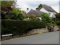
Grade II listed White Cottage, Cotmaton Road, Sidmouth
The thatched cottage dates from the early 19th century, with later additions.
Grade II listed in 1973.
Image: © Jaggery
Taken: 18 May 2017
0.06 miles

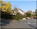
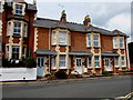
8

Glendevon, Cotmaton Road, Sidmouth
Glendevon is a 3-storey guest house with bed & breakfast accommodation.
Image: © Jaggery
Taken: 18 May 2017
0.07 miles
9
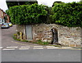
Brook through a Cotmaton Road wall, Sidmouth
A small channelled stream flows through a gap in the wall. Cheese Lane is on the left. http://www.geograph.org.uk/photo/5396937
Image: © Jaggery
Taken: 18 May 2017
0.08 miles
10
Colaton Terrace, Cotmaton Road, Sidmouth
Numbers 1-3 Colaton Terrace are between Glendevon http://www.geograph.org.uk/photo/5397265 on the left and Cheese Lane http://www.geograph.org.uk/photo/5396937 on the right.
Image: © Jaggery
Taken: 18 May 2017
0.08 miles