
IMAGES TAKEN NEAR TO
Barrington Mead, SIDMOUTH, EX10 8QW
Introduction
This page details the photographs taken nearby to Barrington Mead, EX10 8QW by members of the Geograph project.
The Geograph project started in 2005 with the aim of publishing, organising and preserving representative images for every square kilometre of Great Britain, Ireland and the Isle of Man.

There are currently over 7.5m images from over14,400 individuals and you can help contribute to the project by visiting https://www.geograph.org.uk
Image Map
Images are licensed for reuse under creativecommons.org/licenses/by-sa/2.0
Notes
- Clicking on the map will re-center to the selected point.
- The higher the marker number, the further away the image location is from the centre of the postcode.
Image Listing (446 Images Found)
Images are licensed for reuse under creativecommons.org/licenses/by-sa/2.0
Image
Details
Distance
1

Millford Road and Barrington Mead
Mid March and Sidmouth has had its second heavy snow of the year. The River Sid separates the two lots of houses.
Image: © Anthony Vosper
Taken: 18 Mar 2018
0.00 miles
2

Sidmouth floods (10) A close call
Mid afternoon and the River Sid is going down. This was the worst flooding in the town for 16 years.
The strand line shows just how high and close the water got to these houses.
Image: © Anthony Vosper
Taken: 7 Jul 2012
0.02 miles
3

Newtown, Sidmouth
The lane Newtown heads east away from the northern end of High Street.
Image: © Jaggery
Taken: 18 Jun 2013
0.02 miles
4
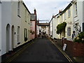
Newtown
Roofing repairs over a wonderful mid Victorian side street off Radway.
Image: © Anthony Vosper
Taken: 23 Oct 2009
0.03 miles
5

Radway Meadow
A grand late Victorian house on Newtown.
Image: © Anthony Vosper
Taken: 14 Mar 2019
0.03 miles
6
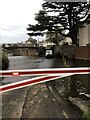
In the river
A van performing maintenance on the River Sid ford gates is used as a work platform whilst the gates are closed.
Mill street, Sidmouth.
Image: © Anthony Vosper
Taken: 27 Nov 2020
0.03 miles
7

Ford crossing the river Sid
The road to the north (right in picture) is Milford Road, and it becomes Mill Road as it crosses the river. There is a warning that the ford is not suitable for cyclists.
Image: © David Smith
Taken: 25 Nov 2010
0.03 miles
8
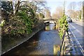
Sidmouth : The River Sid
The River Sid alongside Milford Road.
Image: © Lewis Clarke
Taken: 9 Mar 2014
0.03 miles
9

The Ford on Mill Street, Sidmouth
The ford through the River Sid, Sidmouth. Located at the end of Mill Street you can drive through the river Sid at the old ford. Wonderful watching how different motorists cross the river, some cautious, others making a splash in life.
Image: © Adrian Channing
Taken: 16 Oct 2011
0.03 miles
10
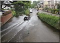
Car fording the River Sid, Sidmouth
At the northern end of Mill Street.
Image: © Jaggery
Taken: 20 May 2018
0.03 miles