IMAGES TAKEN NEAR TO
Sid Road, SIDMOUTH, EX10 8QP
Introduction
This page details the photographs taken nearby to Sid Road, EX10 8QP by members of the Geograph project.
The Geograph project started in 2005 with the aim of publishing, organising and preserving representative images for every square kilometre of Great Britain, Ireland and the Isle of Man.

There are currently over 7.5m images from over14,400 individuals and you can help contribute to the project by visiting https://www.geograph.org.uk
Image Map
Images are licensed for reuse under creativecommons.org/licenses/by-sa/2.0
Notes
- Clicking on the map will re-center to the selected point.
- The higher the marker number, the further away the image location is from the centre of the postcode.
Image Listing (302 Images Found)
Images are licensed for reuse under creativecommons.org/licenses/by-sa/2.0
Image
Details
Distance
1

Sidmouth : Hillside Close
Heading up the hillside and past The Old Farmhouse.
Image: © Lewis Clarke
Taken: 9 Mar 2014
0.02 miles
2

Victorian post box, Sid Road, Sidmouth
Image: © Jonathan Thacker
Taken: 17 Sep 2017
0.03 miles
3

Sidmouth : The Byes
A grassy park in Sidmouth as seen here on a Spring afternoon.
Image: © Lewis Clarke
Taken: 9 Mar 2014
0.03 miles
4
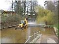
JCB in the River Sid
Removing rocks, swept down river, by recent flood-waters.
Image: © Roger Cornfoot
Taken: 12 Mar 2009
0.03 miles
7
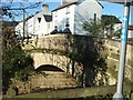
Bridge over River Sid
The bridge carries the Salcombe Road.
Image: © David Smith
Taken: 25 Nov 2010
0.04 miles
8

Autumn colour in the Byes, Sidmouth
Taken from the cycle track through the Byes; this area of the Byes is also known as "The Lawn"
Image: © David Smith
Taken: 29 Oct 2013
0.05 miles
9
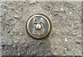
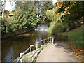
Sidmouth, the Byes, EA Bench Mark
Environment Agency Bench Mark. on a ridge designed to assist with flood protection. In line with the weir and flood wall. Height above sea level not known. More contextual images - see photos:
http://benchmarks.mister.red/#sidmouth
Image: © Mr Red
Taken: 7 Aug 2018
0.05 miles
10

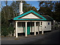
Byes toll house, Sidmouth, and blue plaque
This stands beside the bridge (built in 1817) linking the houses on the east of the River Sid with the town
Image: © David Smith
Taken: 21 Feb 2019
0.05 miles