IMAGES TAKEN NEAR TO
Salcombe Hill Road, SIDMOUTH, EX10 8JR
Introduction
This page details the photographs taken nearby to Salcombe Hill Road, EX10 8JR by members of the Geograph project.
The Geograph project started in 2005 with the aim of publishing, organising and preserving representative images for every square kilometre of Great Britain, Ireland and the Isle of Man.

There are currently over 7.5m images from over14,400 individuals and you can help contribute to the project by visiting https://www.geograph.org.uk
Image Map
Images are licensed for reuse under creativecommons.org/licenses/by-sa/2.0
Notes
- Clicking on the map will re-center to the selected point.
- The higher the marker number, the further away the image location is from the centre of the postcode.
Image Listing (86 Images Found)
Images are licensed for reuse under creativecommons.org/licenses/by-sa/2.0
Image
Details
Distance
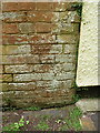
1

Craig Court, bench Mark
An OS cut mark on a house wall.
Image: © Anthony Vosper
Taken: 19 Jun 2015
0.02 miles

3

OS benchmark - Sidmouth, Salcombe Hill
An OS cutmark on Craig Court; originally levelled, probably in 1962, at 44.693m above Ordnance Datum Newlyn.
Image: © Richard Law
Taken: 16 Jul 2017
0.03 miles
4
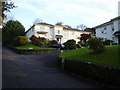
Salcombe Heights
Upmarket flats on Salcombe Hill Road.
Image: © Anthony Vosper
Taken: 1 Nov 2010
0.05 miles

6
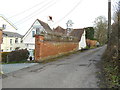
St Kilda's Lodge Alma Lane
Alma Lane was named after the battle during the Crimean War.
St Kilda is an Island of the North West of Scotland.
The building contains an interesting cupola.
An OS Bench Mark can be found close to the white wall.
Image: © Anthony Vosper
Taken: 1 Apr 2018
0.08 miles
7
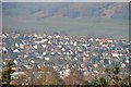
Sidmouth : Town Scenery
Looking across the town of Sidmouth towards houses.
Image: © Lewis Clarke
Taken: 9 Mar 2014
0.08 miles
8
OS benchmark - Sidmouth, St Kilda Lodge
An OS cutmark on the wall of St Kilda Lodge. a house on Alma Lane; originally levelled, probably in 1962, at 59.381m above Ordnance Datum Newlyn.
Image: © Richard Law
Taken: 16 Jul 2017
0.09 miles
9

Alma Lane
Named after a battle in the Crimean offensive.1853 - 1856.
Image: © Anthony Vosper
Taken: 22 Jan 2022
0.10 miles
10

Sidmouth : Horses Grazing
Horses off of Salcombe Hill Road in the outskirts of Sidmouth.
Image: © Lewis Clarke
Taken: 9 Mar 2014
0.10 miles