IMAGES TAKEN NEAR TO
Knowle Gardens, SIDMOUTH, EX10 8HR
Introduction
This page details the photographs taken nearby to Knowle Gardens, EX10 8HR by members of the Geograph project.
The Geograph project started in 2005 with the aim of publishing, organising and preserving representative images for every square kilometre of Great Britain, Ireland and the Isle of Man.

There are currently over 7.5m images from over14,400 individuals and you can help contribute to the project by visiting https://www.geograph.org.uk
Image Map
Images are licensed for reuse under creativecommons.org/licenses/by-sa/2.0
Notes
- Clicking on the map will re-center to the selected point.
- The higher the marker number, the further away the image location is from the centre of the postcode.
Image Listing (52 Images Found)
Images are licensed for reuse under creativecommons.org/licenses/by-sa/2.0
Image
Details
Distance
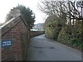
1

Garden wall in Knowle Drive
The wall was originally part of the nearby St John's school which was formerly a convent.
The land was sold off and built upon. The wall was however retained.
Covered in an early clematis, the wall is a fine example of 'garden wall bond' brickwork.
Image: © Anthony Vosper
Taken: 30 Apr 2021
0.03 miles
2
A long wall
the wall originally enclosed the gardens to Sidmouth convent.
It is now a private school. Part of which can be seen in the distance.
Image: © Anthony Vosper
Taken: 5 Jan 2022
0.07 miles
3
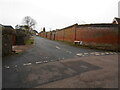
Knowle Drive
The wall to the right was originally part of the grounds to Sidmouth convent.
The convent has now become a private school. With houses being built behind the original walls.
Image: © Anthony Vosper
Taken: 1 Jan 2023
0.08 miles
4
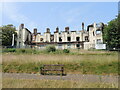
Burned history
The Knowle was firstly an estate of eleven acres, which was built in 1805 for Lord le Despenser and subsequently rented to the Marquis of Bute. It was enlarged with the arrival of Knowle Cottage - a large 30 room house inspired by a mixture of rustic and Gothic features. It changed hands in 1821 when Thomas Leversidge Fish, a noted collector and connoisseur, who added lots of trees, plants, artworks and a menagerie of various animals. He opened the grounds up on Mondays to the publis and with this trade he established a hotel here.
During WWII, the buildings were requisitioned by the military but returned to commercial use thereafter. However, the 1960s saw holiday trade decline and the hotel was bought by Sidmouth Urban District Council for use as their offices. The parkland was left open to all. But by 2015 the council decided it needed to move to better premises and sold it to a care home company, with an eye to conversion. However, the plans were later rejected and the property sold again to a developer in 2022. They hoped to create a more practical mixed residence.
However, in March, 2023, the site was engulfed by a fire that has largely destroyed the historic old suite.
Image: © Neil Owen
Taken: 16 Jun 2023
0.09 miles
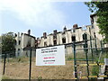
5

Lost in the landscape
Knowle hotel was built around the mid-1800s and prospered until the 1960s, when it was sold for use as offices by the council. Later owners have tried to convert it into mixed residential and care home use, but the site was ravaged by a terrible fire in March this year. The mature woodland and park surrounding it is largely intact although there are some plans to build new housing on it - much to the disdain of the local people.
Image: © Neil Owen
Taken: 16 Jun 2023
0.09 miles
6

Remains in Knowle Park
Originally, the eleven acre site was landscaped with occasional small buildings (perhaps summerhouses or the like), to the designs of Sir Thomas Stapleton, Lord le Despenser. With later owners and expansions there were a number of public attractions too.
Image: © Neil Owen
Taken: 16 Jun 2023
0.10 miles
7

Looking out after the fact
Knowle Hotel was destroyed by a serious fire, and now the security measures are out in force.
Image: © Neil Owen
Taken: 16 Jun 2023
0.10 miles
8
Hopes up in smoke
The old hotel in the Knowle was all but razed to the ground in March this year. Following a protracted recent change of ownership, McCarty Stone were set to convert it into a mixed residential and care use after buying it the previous year. The future now seems open to speculation.
Image: © Neil Owen
Taken: 16 Jun 2023
0.10 miles
9

Broadway, the northern edge of Cotmaton
Image: © David Smith
Taken: 22 May 2011
0.10 miles
10
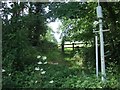
Path into field off Broadway
Broadway marks the northern edge of the Cotmaton area of west Sidmouth
Image: © David Smith
Taken: 22 May 2011
0.10 miles