IMAGES TAKEN NEAR TO
Manor Road, SIDMOUTH, EX10 8FG
Introduction
This page details the photographs taken nearby to Manor Road, EX10 8FG by members of the Geograph project.
The Geograph project started in 2005 with the aim of publishing, organising and preserving representative images for every square kilometre of Great Britain, Ireland and the Isle of Man.

There are currently over 7.5m images from over14,400 individuals and you can help contribute to the project by visiting https://www.geograph.org.uk
Image Map
Images are licensed for reuse under creativecommons.org/licenses/by-sa/2.0
Notes
- Clicking on the map will re-center to the selected point.
- The higher the marker number, the further away the image location is from the centre of the postcode.
Image Listing (418 Images Found)
Images are licensed for reuse under creativecommons.org/licenses/by-sa/2.0
Image
Details
Distance
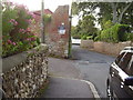
1
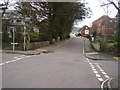
Manor Road junction with Glen Road
The white building to the left is Glenside. The previous building to stand on the site was used by the RAF during WWII as a dental hospital. It went on to become the first Dental Hygienist school in the UK.
An OS Bench Mark can be located on the left hand side of the small bridge.
Image: © Anthony Vosper
Taken: 1 Mar 2014
0.04 miles

3

Cunninghams Lane off Manor Road
Local footpath No6 Linking Manor Road to Cotmaton Road.
Image: © Anthony Vosper
Taken: 14 Nov 2009
0.06 miles
4
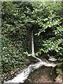
Glen Goyle Waterfall
A man made parkland waterfall. Running off a nearby mill leat.
Runs into the Boughmore brook.
Image: © Anthony Vosper
Taken: 29 Jan 2021
0.06 miles
5
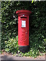
Manor Road letterbox
An Edward VII box by McDowall Steven and comapny, and close to the Manor theatre. See Image] for a location view.
Image: © Neil Owen
Taken: 16 Jun 2023
0.07 miles
6

Along Manor Road in Sidmouth
A letterbox, not far from the theatre. See Image] for a closer look at the old box.
Image: © Neil Owen
Taken: 16 Jun 2023
0.07 miles
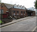
7
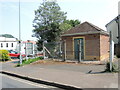
Substation on Manor Road
A small energy infrastructure close to the theatre.
Image: © Neil Owen
Taken: 16 Jun 2023
0.07 miles
8
Seafield Road, Vent pipe
Another example of the Victorian sewage system.
Local footpath No.5 makes its way to the left.
Image: © Anthony Vosper
Taken: 5 Oct 2009
0.08 miles
9

Seafield Road, Sidmouth
From Cotmaton Road along Seafield Road towards Station Road.
The edge of Eaglehurst Court http://www.geograph.org.uk/photo/5399655 is on the left.
Image: © Jaggery
Taken: 18 May 2017
0.09 miles
10
Manor Pavilion Theatre, Manor Road, Sidmouth
Theatre & arts centre opposite Seafield Lane.
Image: © Jaggery
Taken: 18 May 2017
0.09 miles