IMAGES TAKEN NEAR TO
All Saints Road, SIDMOUTH, EX10 8ES
Introduction
This page details the photographs taken nearby to All Saints Road, EX10 8ES by members of the Geograph project.
The Geograph project started in 2005 with the aim of publishing, organising and preserving representative images for every square kilometre of Great Britain, Ireland and the Isle of Man.

There are currently over 7.5m images from over14,400 individuals and you can help contribute to the project by visiting https://www.geograph.org.uk
Image Map
Images are licensed for reuse under creativecommons.org/licenses/by-sa/2.0
Notes
- Clicking on the map will re-center to the selected point.
- The higher the marker number, the further away the image location is from the centre of the postcode.
Image Listing (565 Images Found)
Images are licensed for reuse under creativecommons.org/licenses/by-sa/2.0
Image
Details
Distance
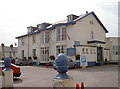
1
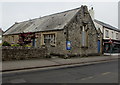
All Saints church hall, Sidmouth
On the north side of All Saints Road east of All Saints' Church. https://www.geograph.org.uk/photo/6430695
Image: © Jaggery
Taken: 20 May 2018
0.01 miles
2
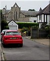
North side of All Saints Church, Sidmouth
The Grade II listed church is part of the Church of England Diocese of Exeter.
Viewed from the southern end of Radway.
Image: © Jaggery
Taken: 20 May 2018
0.01 miles
3

Sidmouth Daycare
Sidmouth Daycare Nursery & Preschool is in All Saints church hall on the north side of All Saints Road Sidmouth.
Image: © Jaggery
Taken: 20 May 2018
0.01 miles
4

OS benchmark - Sidmouth, All Saints Church
An OS cutmark on the porch of All Saints Church; originally levelled, probably in 1962, at 11.61m above Ordnance Datum Newlyn.
Image: © Richard Law
Taken: 18 Jul 2017
0.02 miles
5

Tangles, All Saints Road, Sidmouth
Tangles unisex hair salon is next door to Sidmouth Antique Centre.
Image: © Jaggery
Taken: 20 May 2018
0.02 miles
6

All Saints Church
Under the clock is the message "It is time to seek the Lord"
Image: © David Smith
Taken: 11 Aug 2012
0.02 miles
7

South side of All Saints' Church, Sidmouth
All Saints Road side of the Grade II Listed church in the Church of England Diocese of Exeter. All Saints was built in 1837 on land donated by Sir John Kennaway. It was needed to provide additional Anglican church accommodation as the population of Sidmouth expanded in the early to mid 19th century.
Image: © Jaggery
Taken: 20 May 2018
0.02 miles
8
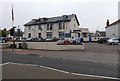
Sidmouth Conservative Club
Set back from the east side of the A375 Radway.
Image: © Jaggery
Taken: 18 Jun 2013
0.02 miles
9
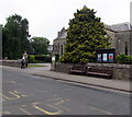
Wooden benches on the north side of All Saints Road, Sidmouth
On the approach to All Saints' Church. https://www.geograph.org.uk/photo/6430695
Image: © Jaggery
Taken: 20 May 2018
0.02 miles
10
Conservative Club
Sidmouth tories' meeting rooms and function venue.
Image: © Neil Owen
Taken: 17 Sep 2014
0.02 miles