IMAGES TAKEN NEAR TO
May Terrace, SIDMOUTH, EX10 8EN
Introduction
This page details the photographs taken nearby to May Terrace, EX10 8EN by members of the Geograph project.
The Geograph project started in 2005 with the aim of publishing, organising and preserving representative images for every square kilometre of Great Britain, Ireland and the Isle of Man.

There are currently over 7.5m images from over14,400 individuals and you can help contribute to the project by visiting https://www.geograph.org.uk
Image Map
Images are licensed for reuse under creativecommons.org/licenses/by-sa/2.0
Notes
- Clicking on the map will re-center to the selected point.
- The higher the marker number, the further away the image location is from the centre of the postcode.
Image Listing (769 Images Found)
Images are licensed for reuse under creativecommons.org/licenses/by-sa/2.0
Image
Details
Distance
1

May Cottage, Sidmouth and blue plaque
The date of the building is uncertain, probably from about 1790 according to the plaque. It is one of the oldest houses in central Sidmouth. For a short time it was used as the town's hospital
Image: © David Smith
Taken: 21 Feb 2019
0.01 miles
2

Dead-end road to Victoria Hospital, Sidmouth
From All Saints Road to the hospital https://www.geograph.org.uk/photo/6430834 in the background.
A Hospital sign is above the No Through Road sign on the left.
Image: © Jaggery
Taken: 20 May 2018
0.01 miles
3

Information outside Sidmouth Victoria Hospital
Text in view on the left here https://www.geograph.org.uk/photo/6430834 in May 2018 includes
FOUNDED IN 1885 - Royal Devon and Exeter NHS Foundation Trust - No Minor Injuries Unit.
Image: © Jaggery
Taken: 20 May 2018
0.01 miles
4

Sidmouth Victoria Hospital
Established in 1885 and in use since that time. However, the modern site is a mixture of various specialist units, minor injuries and cottage hospital uses.
Image: © Neil Owen
Taken: 16 Jun 2023
0.01 miles
5

The Old Meeting, All Saint's Road, Sidmouth
A wedding at the Unitarian Chapel.
Image: © Humphrey Bolton
Taken: 22 Aug 1998
0.02 miles
6

Grade II Listed May Cottage, Sidmouth
The blue plaque https://www.geograph.org.uk/photo/6430654 on the building records that the cottage was built c1790. The first Cottage Hospital for the poor was established 1885-1891 here through the efforts of local benefactress Miss Leigh-Browne. May Cottage was Grade II Listed in 1951.
Image: © Jaggery
Taken: 20 May 2018
0.02 miles
7
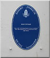
May Cottage blue plaque, Sidmouth
The Historic Sidmouth/Sid Vale Association oval plaque is on the wall of this https://www.geograph.org.uk/photo/6430652 cottage.
Image: © Jaggery
Taken: 20 May 2018
0.02 miles
8
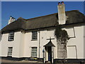
May Cottage
The building is thought to date from the seventeenth century. In 1884, the owner decided to give it over for use as a hospital, and public support was generated. Local benefactor, Annie Leigh Browne (1851 – 1936), donated funds for five years' rent. At first there were four beds and an operating table. In its first year of use, twenty-one patients were admitted and the level of care regarded as very high. In 1891 the Victoria Hospital opened opposite and the cottage then became a school. Grade II listed.
Image: © Neil Owen
Taken: 16 Jun 2023
0.02 miles
9
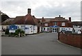
Sidmouth Victoria Hospital
The oldest parts designed by Walter Cave 1892.
Image: © Jonathan Thacker
Taken: 17 Sep 2017
0.02 miles
10

Blackmore House, Sidmouth
The original Blackmore House is gone, but this strangely-shaped building bears the name on the north side, as well as the date of 1904 on a rainwater head. It seems to be a part of the health centre.
Image: © Derek Harper
Taken: 9 Sep 2016
0.02 miles