IMAGES TAKEN NEAR TO
All Saints Road, SIDMOUTH, EX10 8DY
Introduction
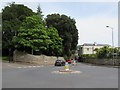
This page details the photographs taken nearby to All Saints Road, EX10 8DY by members of the Geograph project.
The Geograph project started in 2005 with the aim of publishing, organising and preserving representative images for every square kilometre of Great Britain, Ireland and the Isle of Man.

There are currently over 7.5m images from over14,400 individuals and you can help contribute to the project by visiting https://www.geograph.org.uk
Image Map
Images are licensed for reuse under creativecommons.org/licenses/by-sa/2.0
Notes
- Clicking on the map will re-center to the selected point.
- The higher the marker number, the further away the image location is from the centre of the postcode.
Image Listing (452 Images Found)
Images are licensed for reuse under creativecommons.org/licenses/by-sa/2.0
Image
Details
Distance
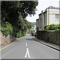
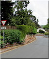
1
East along All Saints Road, Sidmouth
All Saints Road descends towards High Street and the town centre.
Image: © Jaggery
Taken: 18 May 2017
0.00 miles
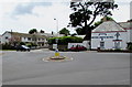
2
Down All Saints Road, Sidmouth
All Saints Road descends from Station Road towards High Street and Sidmouth town centre.
Image: © Jaggery
Taken: 18 May 2017
0.02 miles
3
Station Road mini-roundabout, Sidmouth
At the All Saints Road junction near Woodlands Hotel. http://www.geograph.org.uk/photo/5399531
Image: © Jaggery
Taken: 18 May 2017
0.03 miles
4
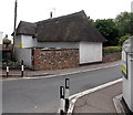
North side of Grade II listed Larbi Cote, Sidmouth
Viewed across Station Road. This thatched cottage is opposite another one, Gwydir Cottage. http://www.geograph.org.uk/photo/3538345
Larbi Cote was Grade II listed in November 1973.
Image: © Jaggery
Taken: 18 Jun 2013
0.04 miles
5
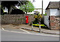
Wallside pillarbox near a thatched cottage, Sidmouth
Alongside Station Road near the thatched cottage named Larbi Cote. http://www.geograph.org.uk/photo/3538379
Image: © Jaggery
Taken: 18 May 2017
0.04 miles
6
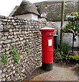
King George V pillarbox, Station Road, Sidmouth
Located here. http://www.geograph.org.uk/photo/5399584 The GR on the box is short for Georgius Rex, Latin for King George,
in this case King George V who reigned from May 1910-January 1936.
Image: © Jaggery
Taken: 18 May 2017
0.04 miles
7
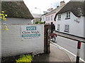
Vote poster on a Station Road wall, Sidmouth
Viewed on May 18th 2017. The independent Claire Wright is one of seven candidates for the East Devon Constituency at the 2017 UK General Election on Thursday June 8th 2017. East Devon has been represented in the House of Commons since 2001 by Hugo Swire of the Conservative Party.
Image: © Jaggery
Taken: 18 May 2017
0.04 miles
8
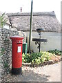
Postbox on the B3176 in Sidmouth
A George V version, by McDowall Stevens.
Image: © Neil Owen
Taken: 16 Jun 2023
0.04 miles
9
Eastern end of Cotmaton Road, Sidmouth
Cotmaton Road descends to the Station Road junction.
Image: © Jaggery
Taken: 18 May 2017
0.04 miles
10

Cedar Shade, Sidmouth from All Saints Road
Listed grade II, the house dates from the early 19th century; it became a hotel and then was divided into apartments. One of Sidmouth's blue plaques is at the gateway
Image: © David Smith
Taken: 21 Feb 2019
0.04 miles