IMAGES TAKEN NEAR TO
Fore Street, SIDMOUTH, EX10 8AF
Introduction
This page details the photographs taken nearby to Fore Street, EX10 8AF by members of the Geograph project.
The Geograph project started in 2005 with the aim of publishing, organising and preserving representative images for every square kilometre of Great Britain, Ireland and the Isle of Man.

There are currently over 7.5m images from over14,400 individuals and you can help contribute to the project by visiting https://www.geograph.org.uk
Image Map
Images are licensed for reuse under creativecommons.org/licenses/by-sa/2.0
Notes
- Clicking on the map will re-center to the selected point.
- The higher the marker number, the further away the image location is from the centre of the postcode.
Image Listing (978 Images Found)
Images are licensed for reuse under creativecommons.org/licenses/by-sa/2.0
Image
Details
Distance
1
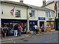
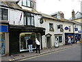
Listed 19th Century row of shops
The 'Cancer Research' shop, and the adjacent 'The Works' together comprise the two Grade II listed buildings dating originally from the 19th Century, and described at https://www.britishlistedbuildings.co.uk/101213653-premises-occupied-by-gainsborough-house-antiques-sidmouth#.WX5GHdQrLGg and https://www.britishlistedbuildings.co.uk/101097940-premises-occupied-by-h-t-scratchley-autioneer-sidmouth#.WX5GqtQrLGg. They were listed in 1973, but have clearly changed hands since then.
Image: © Richard Law
Taken: 15 Jul 2017
0.01 miles
2
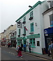
The Black Horse, Sidmouth
Town centre pub at 30 Fore Street.
Image: © Jaggery
Taken: 18 Jun 2013
0.01 miles
3
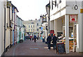
Old Fore Street, Sidmouth
This narrow street contains many historic buildings.
Image: © mike smith
Taken: 16 Mar 2011
0.01 miles
5
Shops on Fore Street, Sidmouth
A row of Grade II listed premises. The nearest (with the black shopfront) rather oddly, appears to miss out on the historical value, but beyond that the lower 'Utopia' was Grade II listed https://www.britishlistedbuildings.co.uk/101333823-premises-occupied-by-c-e-green-fruiterer-sidmouth#.WX5Ej9QrLGg in 1973, at which time it was occupied by a fruiterer.
Image: © Richard Law
Taken: 15 Jul 2017
0.01 miles
6

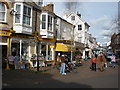
Sidmouth High Street with bunting and flags
Image: © David Smith
Taken: 24 Aug 2018
0.01 miles
8
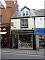
Roly's Fudge Panrty
Just the place for those with an incurably sweet tooth! The serving of fudge just inside the front window was truly enormous - must have weighed 6 or 7lbs.
Image: © Richard Law
Taken: 15 Jul 2017
0.02 miles
9

The Black Horse
Located on the west side of Fore Street, and backing onto Old Fore Street, this pub dates from the late 18th or early 19th Century, and was Grade II listed https://www.britishlistedbuildings.co.uk/101288890-the-black-horse-public-house-sidmouth#.WX7KJoQrKM8 in 1973.
Image: © Richard Law
Taken: 15 Jul 2017
0.02 miles
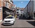
10

Sidmouth: High Street becomes Fore Street and Old Fore Street
The main carriageway descends along Fore Street, to the left, towards the seafront while Old Fore Street heads into the heart of town to the right.
A clock marking the centenary of the Rotary movement, installed in 2005, stands on the wall between the two roads.
Image: © Chris Downer
Taken: 29 Jan 2011
0.02 miles