IMAGES TAKEN NEAR TO
Robert Way, SIDMOUTH, EX10 0SP
Introduction
This page details the photographs taken nearby to Robert Way, EX10 0SP by members of the Geograph project.
The Geograph project started in 2005 with the aim of publishing, organising and preserving representative images for every square kilometre of Great Britain, Ireland and the Isle of Man.

There are currently over 7.5m images from over14,400 individuals and you can help contribute to the project by visiting https://www.geograph.org.uk
Image Map
Images are licensed for reuse under creativecommons.org/licenses/by-sa/2.0
Notes
- Clicking on the map will re-center to the selected point.
- The higher the marker number, the further away the image location is from the centre of the postcode.
Image Listing (74 Images Found)
Images are licensed for reuse under creativecommons.org/licenses/by-sa/2.0
Image
Details
Distance
1
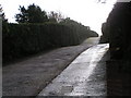
Footpath and driveway leading from the car park
Image: © Rob Purvis
Taken: 9 Dec 2009
0.02 miles
2

Village pump at Newton Poppleford
No longer used, this pump is on the Green Bank, beside the main street of Newton Poppleford. Now a flower planter.
Image: © Sheila Russell
Taken: 13 Nov 2005
0.04 miles

4

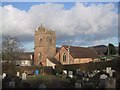
St Luke's Churchyard
Most churchyards fill up from the church and work outwards.
In this case the church is behind the photographer and the oldest graves in the distance. One could surmise that the ground in the foreground was at some point not owned by the church.
Image: © Anthony Vosper
Taken: 3 Oct 2009
0.05 miles

6
The Village School
Situated in the aptly named School Lane, Newton Poppleford.
Image: © Anthony Vosper
Taken: 3 Oct 2009
0.06 miles
7

No access to the churchyard
The West gate to the churchyard for some reason is padlocked shut.
Image: © Anthony Vosper
Taken: 11 Sep 2020
0.06 miles
8

Grave slab, Newton Poppleford
This is on the west wall of the tower of St Luke's Church, and mentioned in the listed building description http://list.english-heritage.org.uk/resultsingle.aspx?uid=1281606&searchtype=mapsearch . I've cranked up the contrast, but much of it is difficult to read. It commemorates William Tilke; his date of death is November 17??, when he was aged 48.
Image: © Derek Harper
Taken: 19 Aug 2013
0.06 miles