IMAGES TAKEN NEAR TO
Cotford Road, SIDMOUTH, EX10 0SG
Introduction
This page details the photographs taken nearby to Cotford Road, EX10 0SG by members of the Geograph project.
The Geograph project started in 2005 with the aim of publishing, organising and preserving representative images for every square kilometre of Great Britain, Ireland and the Isle of Man.

There are currently over 7.5m images from over14,400 individuals and you can help contribute to the project by visiting https://www.geograph.org.uk
Image Map
Images are licensed for reuse under creativecommons.org/licenses/by-sa/2.0
Notes
- Clicking on the map will re-center to the selected point.
- The higher the marker number, the further away the image location is from the centre of the postcode.
Image Listing (187 Images Found)
Images are licensed for reuse under creativecommons.org/licenses/by-sa/2.0
Image
Details
Distance
2
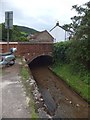
Bridge over Beacon Goyle
Several small boys were playing in the goyle, and had arranged stones on the concrete stream-bed to divert the flow
Image: © David Smith
Taken: 21 Aug 2012
0.03 miles
3
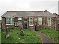
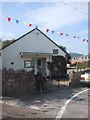
Sidbury Church of England Primary School
Image: © Jonathan Thacker
Taken: 18 Sep 2018
0.03 miles
4

Old Milestone by the A375, Cotford Road, Sidbury
Carved stone post by the A375, in parish of Sidmouth (East Devon District), Sidbury, Cotford Road, 50m North of school entrance; opposite Bowine Cottage, in wall under high hedge, on West side of road. Sidmouth tombstone, erected by the Honiton & Sidmouth turnpike trust in the 19th century.
Inscription reads:-
VI
MILES
FROM
HONITON
III
SIDMOUTH
Devon & Dartmoor HER.
HER Number: MDV38979 https://www.heritagegateway.org.uk/Gateway/Results_Single.aspx?uid=MDV38979&resourceID=104
Milestone Society National ID: DV_HNSM06
Image: © Alan Rosevear
Taken: 29 Jul 2011
0.03 miles
9
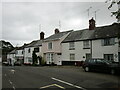
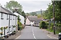
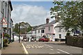
Fore Street, Sidbury
Early nineteenth century houses.
Image: © Jonathan Thacker
Taken: 18 Sep 2018
0.04 miles
10
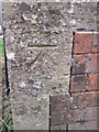
Ordnance Survey Cut Mark
This OS cut mark can be found on No1 Ridgeway Close. It marks a point 56.261m above mean sea level.
Image: © Adrian Dust
Taken: 27 Mar 2015
0.04 miles