IMAGES TAKEN NEAR TO
Sidbury, SIDMOUTH, EX10 0QR
Introduction
This page details the photographs taken nearby to EX10 0QR by members of the Geograph project.
The Geograph project started in 2005 with the aim of publishing, organising and preserving representative images for every square kilometre of Great Britain, Ireland and the Isle of Man.

There are currently over 7.5m images from over14,400 individuals and you can help contribute to the project by visiting https://www.geograph.org.uk
Image Map
Images are licensed for reuse under creativecommons.org/licenses/by-sa/2.0
Notes
- Clicking on the map will re-center to the selected point.
- The higher the marker number, the further away the image location is from the centre of the postcode.
Image Listing (9 Images Found)
Images are licensed for reuse under creativecommons.org/licenses/by-sa/2.0
Image
Details
Distance
1
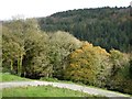
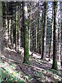
Harcombe Hill Plantation
A large area of woodland in the valley, mixed deciduous and coniferous
Image: © David Smith
Taken: 14 Nov 2014
0.10 miles
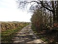
3
Bridleway near Lower Sweetcombe Farm
The bridleway follows the farm access road from Hatway Hill
Image: © David Smith
Taken: 14 Nov 2014
0.14 miles
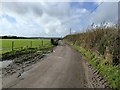
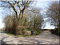
4
Approaching Sweetcombe
Sidmouth Bridleway 91 joins a track as it runs along the side of the Sid valley. A gable end of the farmhouse at Sweetcombe is just visible on the right. Perhaps there was an orchard to the right, but only three trees remain.
Image: © Derek Harper
Taken: 28 Mar 2007
0.15 miles
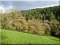
5
Conifer woodland in Stoney Hill Plantation
Image: © David Smith
Taken: 14 Nov 2014
0.18 miles
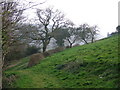
7
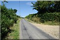
Hatway Hill, Sidbury
The view up Hatway Hill, Sidbury, east Devon.
Image: © Kevin Hale
Taken: 16 Jul 2006
0.20 miles
8
Harcombe Hill Plantation
Woodland on both sides of the valley, with deciduous trees as field boundaries
Image: © David Smith
Taken: 14 Nov 2014
0.21 miles
9
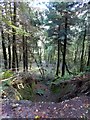
Subsidence in Stoney Hill Plantation
A steep drop beside the footpath (forest track); not really sure what has happened here, as there doesn't appear to be enough spoil at the foot of the hole
Image: © David Smith
Taken: 14 Nov 2014
0.24 miles