IMAGES TAKEN NEAR TO
Trow Hill, SIDMOUTH, EX10 0PW
Introduction
This page details the photographs taken nearby to Trow Hill, EX10 0PW by members of the Geograph project.
The Geograph project started in 2005 with the aim of publishing, organising and preserving representative images for every square kilometre of Great Britain, Ireland and the Isle of Man.

There are currently over 7.5m images from over14,400 individuals and you can help contribute to the project by visiting https://www.geograph.org.uk
Image Map
Images are licensed for reuse under creativecommons.org/licenses/by-sa/2.0
Notes
- Clicking on the map will re-center to the selected point.
- The higher the marker number, the further away the image location is from the centre of the postcode.
Image Listing (6 Images Found)
Images are licensed for reuse under creativecommons.org/licenses/by-sa/2.0
Image
Details
Distance
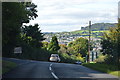
2

A3052, Trow Hill
Heading east up the hill.
Image: © Pierre Terre
Taken: 20 Jun 2009
0.10 miles
3
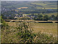
Hogweed above Sidford
Hogweed growing by the A3052 on the hill to Trow above Sidford (seen in the background)
Image: © Derek Harper
Taken: 15 Jun 2006
0.11 miles
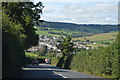
6

The A3052 heading up a steep hill, east of Sidford
Image: © Rob Purvis
Taken: 29 Apr 2024
0.19 miles